0302L-WEDNESDAY OUTLOOK FROM GARFIELD COUNTY EMERGENCY MANAGEMENT-7/26/23
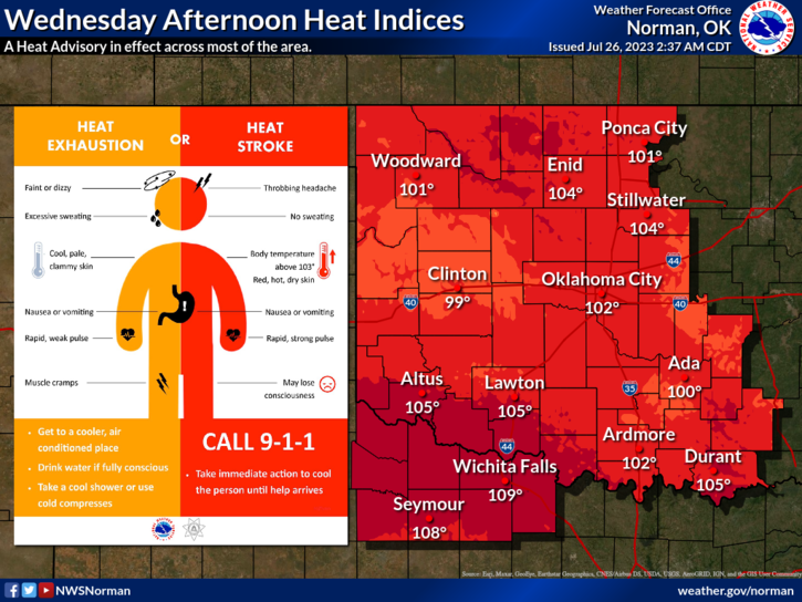
*HEAT ADVISORY IN EFFECT TODAY(WEDNESDAY) FROM NOON UNTIL 8PM TONIGHT. HEAT INDEX VALUES FROM 100 UP TO 108 IN SOME AREAS OF THE STATE ARE POSSIBLE. USE EXTREME CAUTION while working outdoors and take frequent breaks.
*The FIRE DANGER continues to slowly creep upwards. If you decide to do any controlled burning, know, and understand the laws and regulations before setting a fire. Here is a link: https://www.ok-pba.org/laws-and-regulations Just remember, if it gets out of control, call 911 and if you are going to do a controlled burn, call 580-234-FIRE (3473).
*Not too much else to discuss this morning other than there is a “very slight” chance there might be a shower here in Northern Oklahoma this morning from the remnants of activity that occurred overnight in Kansas. They are dissipating as I type so just keep this in mind. All these would do is increase the humidity. We’ll see what happens.
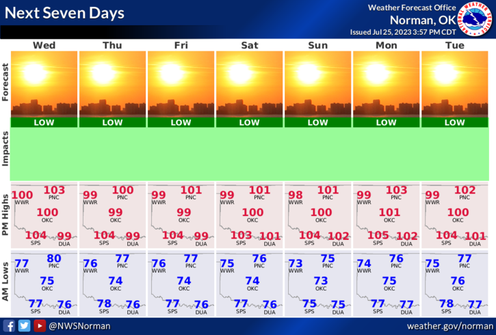
*Overall, we’ll be ok, just a bit toasty, so here is your forecast from the NWS/NORMAN;
Today-Mostly sunny. Hot, with highs around 102. Heat Index near 105. Southwest winds 15 to 20 mph with gusts up to 30 mph.
Tonight-Mostly clear in the evening, then becoming partly cloudy. Lows in the upper 70s. South winds 10 to 15 mph with gusts up to 25 mph. Heat index values up to 105 early in the evening.
HAVE A SUPER DAY & STAY COOL