0310L-TUESDAY OUTLOOK FROM GARFIELD COUNTY EMERGENCY MANAGEMENT- 2/11/25
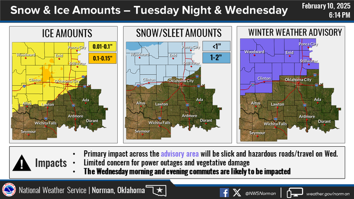
*WINTER WEATHER ADVISORY IN EFFECT FROM 6PM TODAY UNTIL NOON WEDNESDAY. Impacts are mainly roads, bridges & overpasses becoming slick and hazardous. Slow down if driving.
For today, rainfall is possible along with freezing mist this morning. Slight lull this afternoon and then this evening, the winter weather ramps up. As stated in earlier posts, road conditions will deteriorate so plan accordingly. ICE AND SNOW will be the main threats on roadways. Use extreme caution if you have to be out.
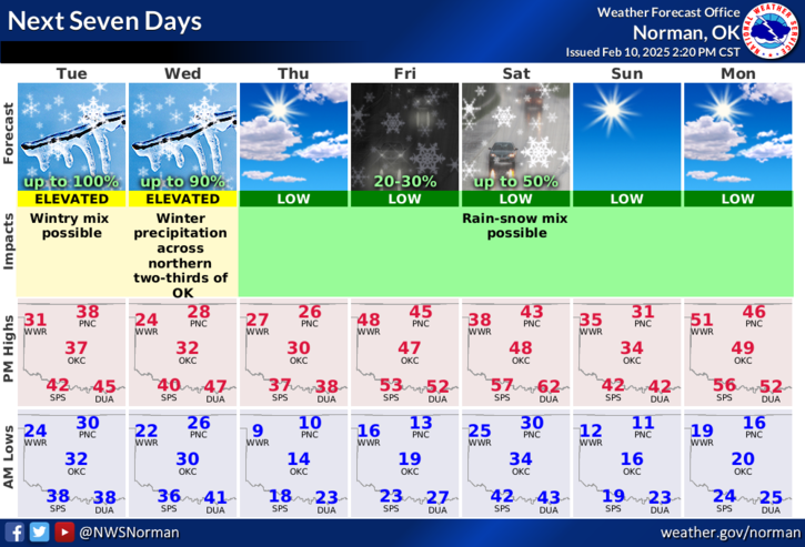
Overall, we’ll be ok so here’s your forecast from the NWS/NORMAN;
Today- Cloudy. A slight chance of rain, freezing rain and snow this morning. Highs in the mid-30s. Northeast winds 10 to 15 mph with gusts up to 25 mph. Chance of precipitation 20 percent.
Tonight- Chance of snow, rain and freezing rain in the evening, then freezing rain, snow, rain with a slight chance of sleet after midnight. Little or no snow and sleet accumulation. Ice accumulation of up to a tenth of an inch. Cold with lows in the mid-20s. Northeast winds 10 to 15 mph. Chance of precipitation near 100 percent.
Download our GARFIELD COUNTY EM app. You’re better prepared with it than without it.
HAVE A GOOD DAY!