0345L-FRIDAY OUTLOOK FROM GARFIELD COUNTY EMERGENCY MANAGEMENT-4/12/19
FROST ADVISORY UNTIL 9 AM THIS MORNING. If young plants were left outside uncovered, they may suffer due to freezing conditions.
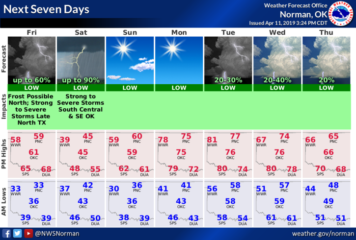
1- I’ll start with your forecast from the NWS/NORMAN; Today-Increasing clouds with highs around 60. North winds around 10 mph in the morning becoming light and variable.
Tonight- Mostly cloudy with a slight chance of rain showers after midnight. Lows in the upper 30s. Light and variable winds becoming northeast 10 to 15 mph after midnight. Chance of showers 20 percent.
2- April is that month where winter and spring have issues. Depending on actual conditions, anything can happen. This is why we state to keep your coats handy because you never know. Today will be mild but tomorrow will be wet, chilly, and miserable. Sunday appears to look ok at least right now. Overall, no severe weather for our area but there may be some flurries around the region. If you plan on traveling, severe weather is forecast to the south and southeast. Some winter weather is forecast for areas to our northwest. CHECK YOUR FORECASTS here and at your destination and understand what may happen in between. Most folks don’t do this and end up with a weather surprise. DON’T be those folks.
3- Overall, we’ll be ok so just be prepared for all seasons this weekend depending on your perspective.
Have a great day!!
MIKE