0400L-FRIDAY OUTLOOK FROM GARFIELD COUNTY EMERGENCY MANAGEMENT-5/7/21
1-Another nice day but windy with a chance for showers early, then showers again late during the overnight hours. We expect a cold front to push in sometime Saturday evening bringing chances for thunderstorms with it. We do have a strong cap above us so rain chances could be hindered by this. Lots of variables to deal with so we’ll see what happens.
2- Keep in mind, these variables don’t mean nothing will happen so keep your guard up but don’t change your plans. Stay weather aware and make sure you have our GARFIELD COUNTY EM app. This keeps you prepared and notified when things may get out of hand. Lots of good info that just might save your life someday.
3- Here is your forecast from the NWS/NORMAN;
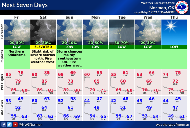
TODAY-A slight chance of showers and thunderstorms between 7am and 10am. Mostly sunny, with a high near 81. South wind 10 to 15 mph increasing to 15 to 20 mph in the afternoon. Winds could gust as high as 28 mph. Chance of precipitation is 20%.
TONIGHT-A 30 percent chance of showers and thunderstorms, mainly before 1am. Mostly cloudy, with a low around 63. South southeast wind 10 to 20 mph, with gusts as high as 25 mph.
HAVE A GOOD DAY!!
MIKE