0330L-SATURDAY OUTLOOK FROM GARFIELD COUNTY EMERGENCY MANAGEMENT 03/23/24
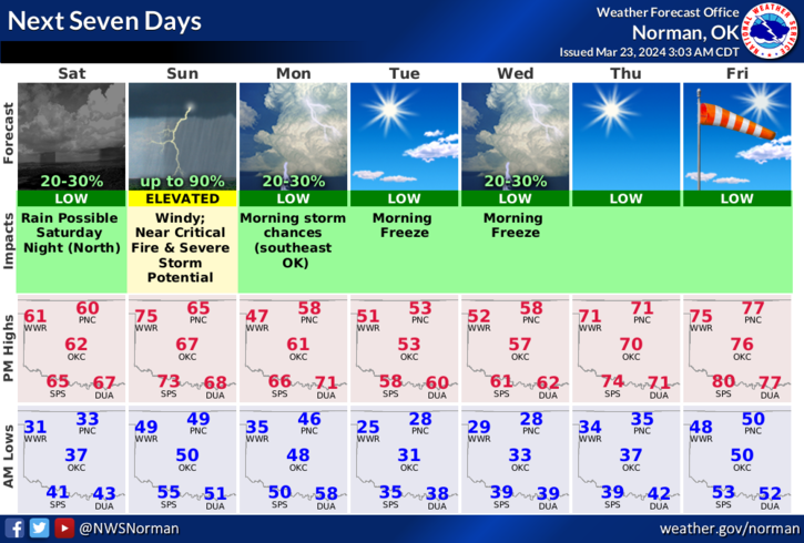
*Enjoy today! Light winds, mostly sunny, and generally just nice. Sunday will be a different story with winds being the main issue, along with fire weather and possibly severe thunderstorms. Since guidance changes a little for Sunday, we’ll focus on today; after a cool start this morning, we’ll warm up into the 60s with light winds and then rain chances, though low, come into play late tonight into early Sunday morning. Winds today will start out northeasterly then become southeasterly around mid-afternoon but will remain rather light.
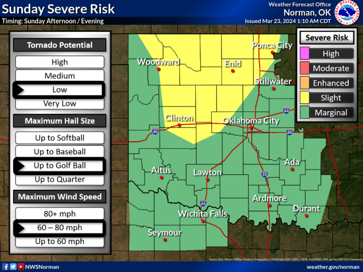
*As for Sunday, secure anything on your property that could take flight, no controlled burning, is advised since those will get out of control real quick, and be prepared for severe weather with all hazards possible. Make sure you have a plan for any hazard that could occur just in case. We’ll keep an eye out and advise as needed. Overall, we’ll be ok so here is your forecast from the NWS/NORMAN;
Today-Sunny. Highs around 60. Northeast winds 5 to 10 mph, becoming southeast this afternoon.
Tonight-Mostly cloudy. A slight chance of showers after midnight. Breezy and not as cool with lows in the upper 40s. Southeast winds 10 to 15 mph, becoming south 15 to 25 mph with gusts up to 35 mph after midnight. Chance of rain 20 percent.
*As stated over the last few days, here is the next item to review Lightning Safety. I know everyone feels they know mostly everything you need to know but there just may be something under this title that would be a good review. Here is the third link- https://www.weather.gov/safety/lightning
FINALLY, make sure you download our GARFIELD COUNTY EM app as you’ll receive advisories and warnings “directly” from the NWS, IN DETAIL. You’ll also receive info from us.
HAVE A GOOD DAY!