0350L-THURSDAY OUTLOOK FROM GARFIELD COUNTY EMERGENCY MANAGEMENT-8/27/2020
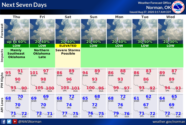
1- WARM temps again today with rain chances beginning as early as Friday night. Our storms, if they occur, will be due to a weak cold front that will linger around the area over the weekend. High temps will still be around 90 per guidance from the NWS.
2- For the most part, rain chances will remain low over the weekend so get out and get the yards done just in case. Be careful in the heat as the humidity will be higher thus the HEAT INDEX will be back in the picture. HYDRATE PROPERLY so you don’t have heat issues. We’ll be in a MARGINAL RISK at least for now for possibly severe weather late Saturday afternoon and evening. The risks, if they occur will be hail and winds.
3- Cooler weather is expected next week but models are NOT in total agreement again per guidance from the NWS. We’ll see what happens as we take each day accordingly.
4- Here is your countywide forecast from the NWS/NORMAN;
Thursday- Mostly sunny. Highs in the lower 90s. South winds around 10 mph.
Thursday Night- Mostly clear. Lows in the upper 60s. Southeast winds around 10 mph in the evening becoming light and variable.
September 1st will be the beginning of some changes we will be making on posting information from emergency management. Many folks are not getting our info on social media so we will make some changes on our end to make sure you have that info. DOWNLOAD our GARFIELD COUNTY EM app to start with and hopefully with our changes you will receive the info you need.
HAVE A GREAT DAY!!
MIKE