0325L-THURSDAY OUTLOOK FROM GARFIELD COUNTY EMERGENCY MANAGEMENT-12/30/21
1- Mild weather for today and then changes are in the works as a strong cold front moves in our direction. A chance for rain has been added to the forecast for Friday here so we’ll see how that pans out. Severe weather is possible in SE Oklahoma so if you plan on going in that direction, stay alert.
2- Several scenarios could occur as this system moves in. There is a chance for rain and as that rain might be occurring, colder air moves in thus transitioning over to sleet and possibly freezing rain. As the atmosphere cools and even colder air moves in, we could see a transition to snow. TIMING is key here so we’ll have to wait, as we always do, and see how this mess comes together. We might not see any precipitation in this mess so again, we’ll see how it comes together.
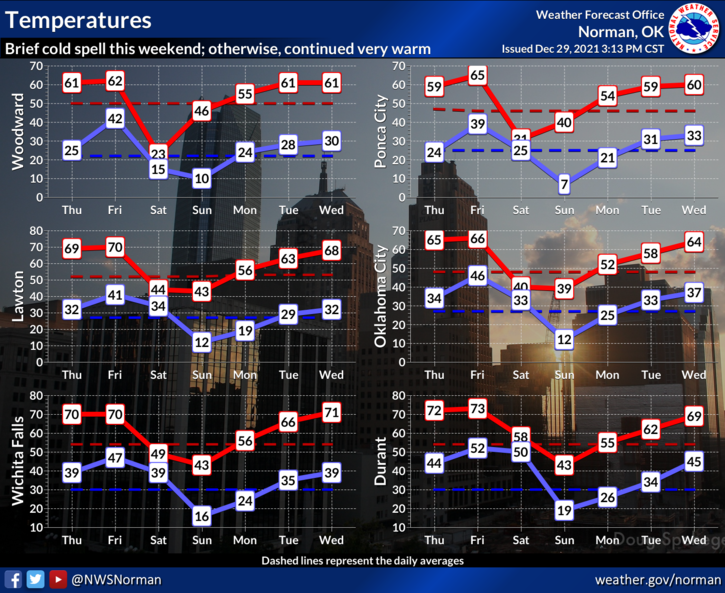
3- The MOST IMPORTANT issue will be the dramatic temperature change. We could see around a 40 degree drop in temps from Friday’s high to Saturdays high so keep this in mind. WIND CHILL temps will be very low so remember that skin could freeze fairly quickly if you don’t cover up.
4- Overall, we will survive this winter event however it transpires so that said, here is your forecast from the NWS/NORMAN;
Today-Mostly sunny. Highs in the lower 60s. Light and variable winds becoming south around 10 mph in the afternoon.
Tonight-Partly cloudy. Not as cool. Lows around 40. South winds around 10 mph.
Have a good day!