0355L-TUESDAY OUTLOOK FROM GARFIELD COUNTY EMERGENCY MANAGEMENT-3/19/19
1-Windy conditions will exist as we get ready for another cold front that should push through the area later today. Rain chances are low so we’ll see what happens as the front moves through the area.
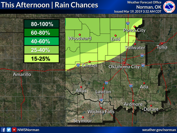
2-Here is your forecast from the NWS/NORMAN;
Tuesday-30 percent chance of showers after 4pm. Mostly sunny with a high near 64. South winds 10 to 20 mph, with gusts as high as 25 mph.
Tuesday Night-50 percent chance of showers. Increasing clouds with a low around 40. North northwest wind 5 to 10 mph becoming southwest in the evening. New precipitation amounts of less than a tenth of an inch possible.
3-Yesterday I spoke of a BACKUP PLAN. What is a backup plan and how does it apply to you?
A backup plan is a plan you revert to in the event your primary plan fails. In my world, we activate the operations center and then realize we are about to take a hit. Our backup plan then becomes mobile. Our options become limited but we can continue to put out information and warnings as before. Where we go is OUT OF DANGER!! If there’s no time to go mobile, then I’ve screwed up!! Backup plan-2 would be to take cover and hope no one gets killed. Backup plan-2 is NOT A GOOD IDEA.
Another way for you to see this is you plan a vacation at a resort. You’re on your way. You have a wreck and you get hurt. You have crutches now so your plans have changed. You rent a car and either continue or go home. Which one becomes your backup plan?
Many factors are involved in planning, backup planning, or contingency planning, so whatever you decide to do, have a backup plan just in case. If you know me well, WHAT IF??
HAVE A GREAT DAY!!
MIKE