0400L-FRIDAY UPDATE FROM ENID/GARFIELD COUNTY EMERGENCY MANAGEMENT-4/20/18
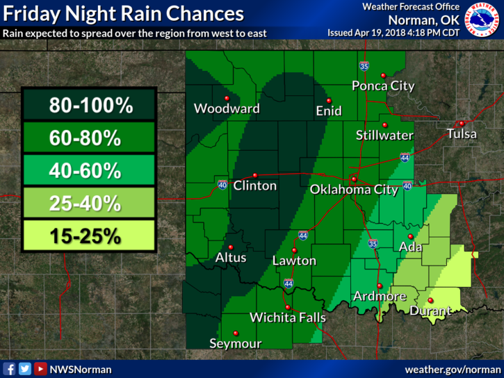
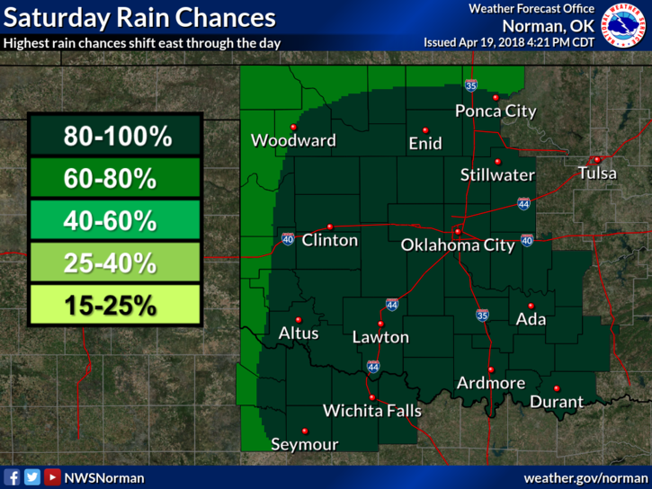
1- Winds will pick up as a storm system approaches the region later today. High rain totals aren’t expected but we could receive up to an inch or so if the present storm track verifies. Let’s just hope we receive some much needed rain. ANYTHING at this point would be a plus.
2- We don’t expect any severe weather as instability is low but always keep in mind this can change. There may be some thunder but overall, we’ll be ok.
3-Per the BURN BAN, I have received many calls about if it rains, can I burn? That answer is NO. BURN BAN means NO BURNING! Quick example- it rains, ground and foliage are wet, rain soaks in, winds dry foliage but the ground is wet, foliage can still catch fire. Wet ground makes it difficult for firefighters to get there. See where I am going with this?? Just don’t burn illegally. It’ll save you, possibly from legal fees.
4-There is a chance for some rain again next week. Hopefully that will occur. Either way, we’ll deal with what Mother Nature decides to throw at us. If it does rain, sit outside on the patio and watch and listen to it. It really does give that calming effect. The last 7 days have been a bit stressful for a lot of us in NW Oklahoma.
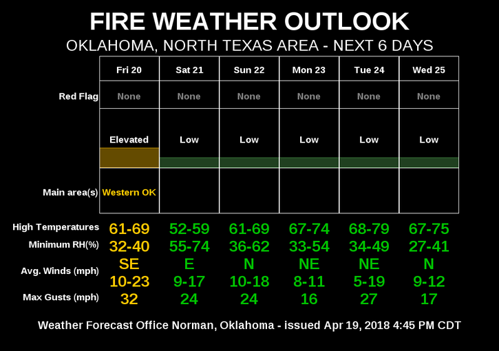
5- Here is your forecast from the NWS/NORMAN;
Friday-Increasing clouds with a high near 65. Southeast winds 10 to 20 mph gusting to 25 mph.
Friday Night-Showers and possibly a thunderstorm after 1am. Low around 44. East southeast winds 10 to 15 mph. Chance of precipitation is 80%. New rainfall amounts between a half and three quarters of an inch possible.
6- THERE IS STILL A FIRE DANGER OUT THERE SO BE EXTREMELY CAREFUL. SEE SMOKE OR FIRE, CALL 911
HAVE A SUPER DAY and be sure to download our GARFIELD COUNTY EM app. It just might save your life!!
MIKE