0340L-FRIDAY OUTLOOK FROM GARFIELD COUNTY EMERGENCY MANAGEMENT-8/7/2020
1-Thunderstorms will be mostly out of the forecast for a few days and the wind will finally be back to dry things out. It will also be humid today and tomorrow but at least the wind will help as a cooling factor for those that work outside. If you plan on traveling, southerly wind gusts may be strong enough to affect driving so be a little extra careful.
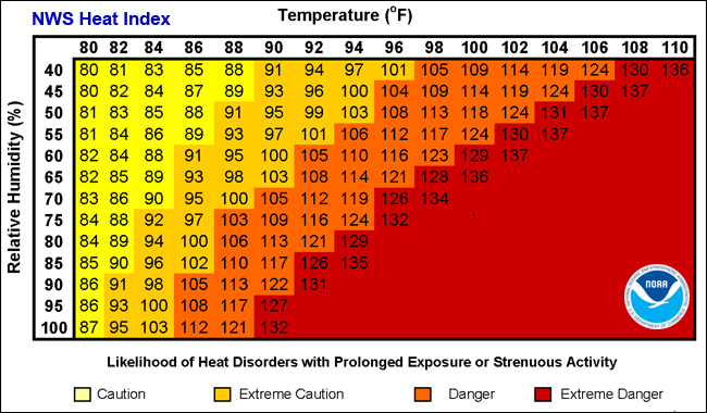
2- The heat index comes back into play starting today so pay close attention to how you are feeling while working outdoors. I’ll attach a graph concerning the heat index to this post. Overall, we’ll be ok so here is your forecast from the NWS/NORMAN;
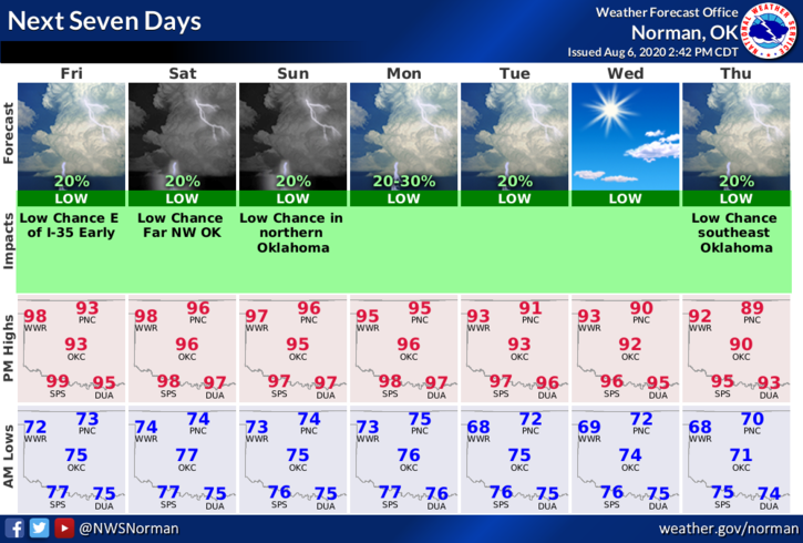
Friday- 30 percent chance of showers and thunderstorms before 7am. Mostly sunny with a high near 94. Heat index values as high as 100. South winds 15 to 25 mph gusting as high as 32 mph.
Friday Night- Mostly clear with a low around 74. South winds 15 to 25 mph gusting as high as 31 mph.
DIRECTORS COMMENT
Here is some food for thought: if we remain in a very moist environment as we move into the winter months and knowing we will be in a LA Nina weather pattern, winter may get very interesting. Temperatures aloft from 5 thousand feet down to the ground determine the precipitation type we have most of the time. A degree or so can mean the difference between snow or ice at different levels. That said, start thinking about how prepared you might or might not be so if and when these events occur, you are ready. WHAT IF? – 1- the power is knocked out, 2- you are iced in and can’t get to the store, 3- cell phone service is knocked out? These are only a few things to consider for this coming winter. As erratic as this summer has been, I would definitely be considering a good winter plan now.
HAVE A SUPER DAY!!
MIKE