405L-FRIDAY UPDATE FROM ENID/GARFIELD COUNTY EMERGENCY MANAGEMENT-7/6/18
1-Rain, maybe heavy rain at times, is possible later today and again on Sunday into next week. The severe threat is low BUT if you end up underneath a strong cell, minor flooding could occur. With storms that collapse, winds could be an issue too. Just stay aware of conditions and you’ll be ok.
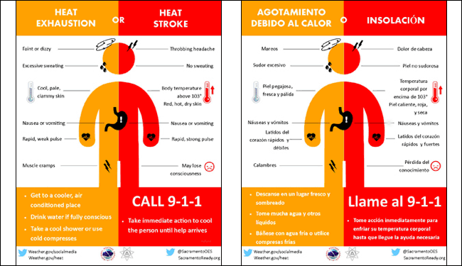
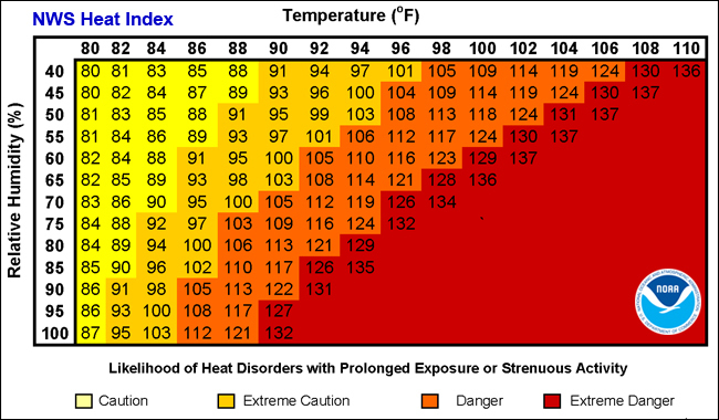
2-Overall, it may be a little cooler but it will be extremely HUMID. Heat indices may be up a bit but not as bad in the recent past. HEAT INDICES should remain in the upper 90’s.
3-Be sure and download our GARFIELD COUNTY EM app. If you don’t have it, you’re not PREPARED!
4- MARK YOUR CALENDARS– OCTOBER 30, 2018, 2ND Annual “Disaster Resilience Seminar” will be held on OCTOBER 30TH FROM 9-4 in the event center. If you want to know from school, utility, emergency, recovery, or insurance personnel what you really need to expect and do before and after something major occurs, you need to attend this seminar. More details forthcoming. BTW- THERE IS NO COST TO ATTEND.
5- Here is your forecast from the NWS/NORMAN;
Friday-20 percent chance of showers and thunderstorms after 1pm. Partly sunny, with a high near 93. Heat index values as high as 99. East northeast wind 5 to 10 mph.
Friday Night-Mostly cloudy, with a low around 72. East northeast wind 5 to 10 mph.
HAVE A SUPER DAY AND STAY COOL!!
MIKE