0415L-FRIDAY OUTLOOK & INFO FROM GARFIELD COUNTY EMERGENCY MGMT-3/20/2020
1- WIND ADVISORY still in effect until 7am this morning. Temps today will be quite a bit colder than yesterday and we should drop below freezing early Saturday morning. Take freezing precautions around the house and at work so pipes don’t break. We should also see some clearing, cloud-wise by this afternoon. We will experience a gradual warm-up over the weekend and then fluctuate some next week.
2-Download our GARFIELD COUNTY EM app and keep up with the latest info from the office of Emergency Management. The COVID-19 ICON when selected on our app will give you information from the CDC and the bottom tab will give you info from our Garfield County Health Department.
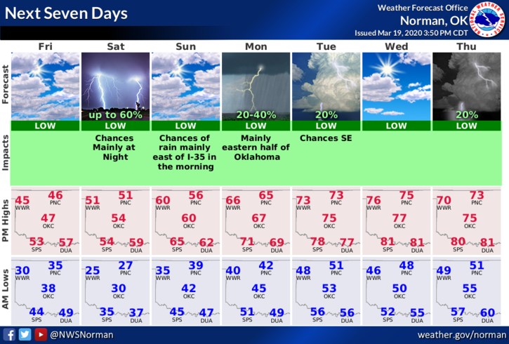
3- Overall, we’ll be ok. Here is your countywide forecast from the NWS/NORMAN;
Today-Mostly cloudy then becoming partly cloudy early in the afternoon then becoming sunny. Much colder. Highs in the mid 40s. North winds 20 to 25 mph decreasing to 10 to 20 mph in the afternoon.
Tonight-Clear. Lows in the mid 20s. North winds 10 to 15 mph in the evening becoming light and variable.
FINALLY; as of this typing, there are no active cases of COVID-19 in Garfield County. I am coordinating efforts with city and county officials to monitor this situation closely. I will post important info as I get it so you will be up to date too. REMEMBER, don’t let the TV MEDIA scare you with their drama. YOU DON’T MAKE GOOD DECISIONS IN AN EMOTIONAL STATE. Remain calm and we’ll get through this.
Have a good day!
MIKE