FROM GARFIELD COUNTY EMERGENCY MANAGEMENT
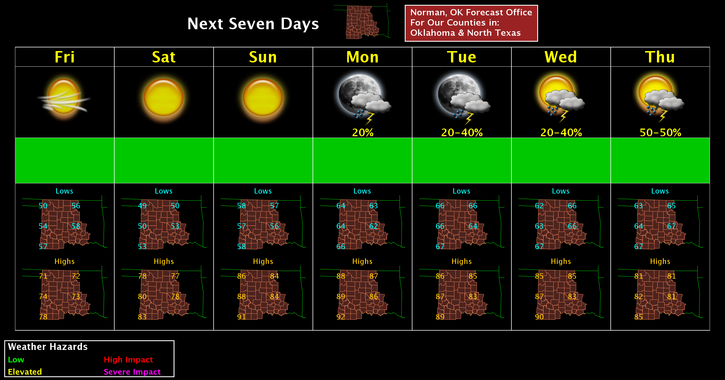
Good morning, we received over another inch of rain yesterday as more storms traversed through the area, The rain is over for at least a few more days then we’ll start getting into our more common May severe pattern starting Tuesday. There are still several questions as to timing, moisture return, heating, and the capping inversion but overall, we will see strong to severe weather most days next week.
That said we’ll keep an eye out as all this mess comes together and advise accordingly. Today, it will be cool and then over the weekend it will begin to get HOT so dress accordingly. I know I have said this before but TAKE PREVENTATIVE PRECAUTIONS for mosquitoes out there. West Nile Virus is still around and you don’t want to contract that. Having had a TICK BORNE ILLNESS last summer, you definitely don’t want that either. Check yourself and the kids for ticks if they have played in a wooded area or in tall grass. BE PREPARED AND TAKE PRECAUTIONS. It will save you from feeling horrible. Believe me.
That said, here is your forecast from the NWS/NORMAN;
Friday-Mostly sunny, with a high near 71. North wind 10 to 14 mph, with gusts as high as 20 mph.
Friday Night-Clear, with a low around 49. North northeast wind 5 to 9 mph becoming calm in the evening.
HAVE A SUPER DAY!!
MIKE