0330L- FRIDAY OUTLOOK FROM GARFIELD COUNTY EMERGENCY MANAGEMENT-11/11/22
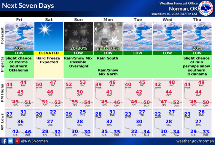
1- FREEZE WARNING IN EFFECT FROM 8 PM THIS EVENING UNTIL 9 AM SATURDAY. This is to cover all of the NWS/NORMAN warning area since all areas didn’t get below freezing in late October. We should see a hard freeze both Saturday and Sunday mornings.
2- Cooler temps but mostly winds will be the major issues today. Low 40’s temps and wind gusts around 30 will keep wind chill temps around freezing so wear a coat and stay warm if you work, play, or just want to be outdoors. The NWS issued the freeze warning due to forecast temps dropping to near 20 degrees.
3- Over the next 4 to 5 days with other systems moving through the area, there is a chance for a rain/snow mix during the overnight periods as they move through the area. Keep in mind that when we reach freezing temps that any rain will become freezing rain and roads may get a bit tricky so slow down and pay close attention to driving conditions. For those that like to speed, run stop signs, traffic lights while paying more attention to your phones, you may end up in an accident. That will be hard to explain.
4- Overall, we’ll be ok so pay attention to the weather conditions and stay warm. Here is your forecast from the NWS/NORMAN;
Today-Mostly sunny. Much cooler with highs in the lower 40s. North winds 15 to 20 mph with gusts up to 35 mph.
Tonight-Partly cloudy in the evening, then becoming clear. Cold with lows in the lower 20s. North winds 5 to 10 mph.
Have a good day!