FROM GARFIELD COUNTY EMERGENCY MANAGEMENT
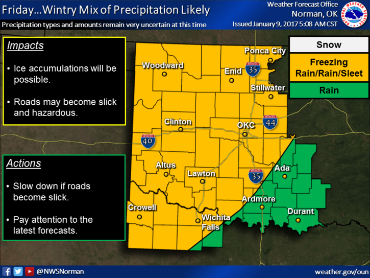
THE PANIC HAS ALREADY BEGUN!!! Don’t believe ANYONE out there that is showing any prediction about depth of ice or snow as it’s impossible to determine that this far out. It amazes me that folks will even put this out there but our society is loaded with fraud so we deal with it. This said, yes, we will see some sort of winter precip this Friday into the weekend BUT storm track, atmospheric conditions, moisture placement can’t be determined FOR SURE until we are closer to the event.
Winter storms systems can veer one way or the other and let’s say 50 miles either way can have a major impact on certain areas. We aren’t really sure what the depth of the cold air will be and that is the main issue. Right now, just be prepared for a winter event and we’ll deal with what Mother Nature throws at us. Keep up with the latest information from the NWS and UNDERSTAND the forecast will change a little each day AS THE EVENT GETS CLOSER.
Here is a link to The Forecast Discussion in Norman. Take some time and read this. Welcome to my world!! This shows you that even the professionals have MANY questions about what MAY happen. Here is the link: http://forecast.weather.gov/product.php?site=OUN&product=AFD&issuedby=OUN
ALSO, Here is a special weather statement issued a little bit ago; http://forecast.weather.gov/wwamap/wwatxtget.php?cwa=oun&wwa=special%20weather%20statement
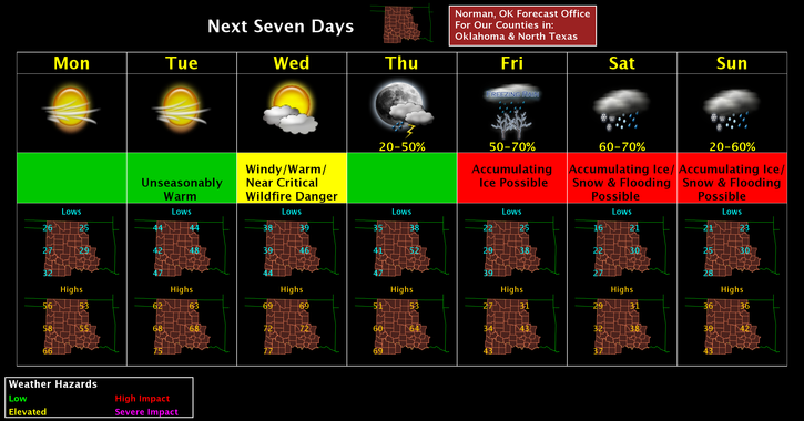
Here is your forecast from the NWS /NORMAN;
Today-Sunny, with a high near 52. South wind 8 to 18 mph, with gusts as high as 25 mph.
Tonight-Cloudy, then becoming partly cloudy toward daybreak, with a low around 44. South southwest wind 16 to 20 mph, with gusts as high as 28 mph.
HAVE A SUPER DAY!!
MIKE