FROM GARFIELD COUNTY EMERGENCY MANAGEMENT
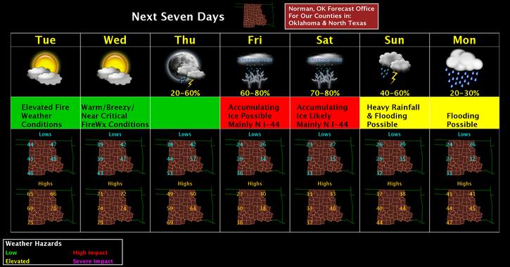
GOOD MORNING, It appears we are still on track for some wintery precipitation for this weekend. There are still many questions out there as for precip type for sure, duration of the event, actual storm track, and several others. When you have to factor in cold fronts that move through the area, stall out, then back up as a warm front, large storm systems that are still way out west and really haven’t formed a definitive track through our area, factoring the amount of moisture possibly coming up from the gulf and worse yet, the moisture coming WITH THE STORM SYSTEM from the Pacific. Now take in climatology of our area now along with surface temps and temperatures aloft at various heights. If you can figure out what will definitely happen in 3 to 5 days, call me.
The precip map on the graphicasts looks the way it does because all the above hasn’t been determined and it may not be determined until the day before or even the “days” of the event. This is the issue I have with all the panic being spread out there. Here is my analogy for what we can expect based on today’s discussions from 5 NWS offices around the region; YES, we may receive some rain initially. Yes, we may see and receive some freezing rain. We MIGHT even see some snow at some point. IT’S TOO EARLY to make FINAL DETERMINATIONS at this time. STAY TUNED TO ALL NWS/NORMAN updates and you’ll know most of what we will know.
That said, PREPARE for a WINTER EVENT. IT WILL INCLUDE DIFFERENT TYPES OF WINTER PRECIPITATION. We have had these before and we survived. I don’t see a different outcome this time. Will we be inconvenienced? MAYBE, but again, it’s happened before and we survived. Make sure you have enough food, water, and whatever else you may require to get through the weekend. DON’T PANIC BUY ANYTHING. We’ll be ok. Take the next several days and just make sure you have what you need. If you don’t have something, go get it!!
Finally, we’ll sit back and watch what Mother Nature throws at us and then we’ll deal with it. Here is your forecast from the NWS/NORMAN;
Tuesday-Sunny, with a high near 63. Southwest wind 12 to 17 mph becoming south southwest 6 to 11 mph in the afternoon. Winds could gust as high as 24 mph.
Tuesday Night
Mostly cloudy, with a low around 43. South wind 5 to 13 mph.
Have a super day and I may do a video sometime today as updates become available.
MIKE
P.S. Here is a link to the Norman Forecast discussion this morning; Welcome again to my world;