0320L-MONDAY OUTLOOK FROM GARFIELD COUNTY EMERGENCY MANAGEMENT 03/11/24
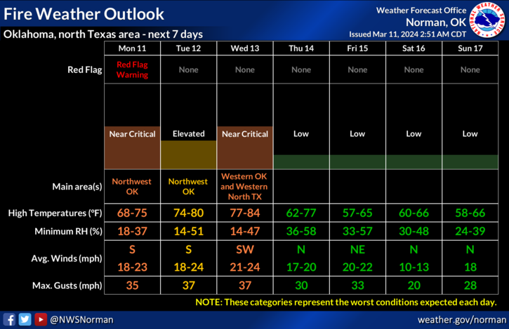
*RED FLAG WARNING in effect for Ellis, Harper, and Woodward counties from 1pm until 7pm.
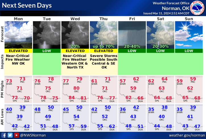
*Warm temps near 70 today, mid to upper 70’s on Tuesday, and near 80 on Wednesday will bring in strong winds and an increase in the FIRE DANGER. The danger will be higher out west as it appears right now.
*A weak cold front is forecast to push into the state on Tuesday but stall out and move back north as a warm front. That said, we expect a stronger front to push in late Wednesday night into Thursday morning. Rain chances for us are low. We’ll see what happens. The wind gradient will remain fairly tight so expect winds to remain pretty strong.
*As stated yesterday, we request that there be NO controlled burning since wind gusts will exceed 15 mph for the next several days. If the winds die down enough and you decide to do a burn, CALL DISPATCH at 580-234-3473 and let them know, then make sure you get the edges of that burn put out completely as it will only take a spark from an ember to cause a major problem. Just use extreme caution, common sense, and be careful. Winds will gust higher than 15 mph through Wednesday, even in the evening so I would hold off burning for now. We would appreciate it.
Other than the fire danger out there, dirt will fly so use caution while driving, especially on east/west roadways. Overall, we’ll be ok so here is your forecast from the NWS/NORMAN;
Monday-Sunny, with a high near 71. South wind 9 to 14 mph increasing to 15 to 20 mph in the afternoon. Winds could gust as high as 30 mph.
Monday Night-Partly cloudy, with a low around 50. South wind 10 to 20 mph, with gusts as high as 30 mph.
HAVE A GOOD DAY!