0400L-SATURDAY OUTLOOK & INFO FROM GARFIELD COUNTY EMERGENCY MGMT-3/4/2020
1-NWS guidance states that by this evening, we’ll be back to southerly flow and we’ll warm back up. That would be nice. Cold weather that hit us yesterday can stay away till next winter. Overall, we did survive the cold and we’ll survive spring and summer too. Cloud cover will thin and we should become partly cloudy as the day progresses. I hope that all crops out there weren’t damaged by the sub-freezing temps yesterday, time will tell. That said, here is your forecast from the NWS/NORMAN;
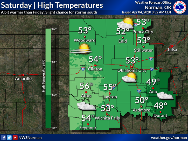
Today-Partly cloudy with highs in the lower 50s. Northeast winds around 10 mph.
Tonight-Partly cloudy with lows in the upper 30s. Light and variable winds.
2- From spring to Covid-19, to winter, and now to several intense earthquakes near Fairmont. If any resident suffered damage from those two earthquakes, let me know. If anyone notices open cracks in the ground, let me know there too. I will get with the Fairmont Fire Chief today to assess the area. There is a small fault type structure that runs through that area so we’ll check it out. Never a dull moment in the life of an emergency manager.
3- Finally, I received several texts concerning my post using caps. CAPS do not mean I am yelling. Whoever made that up is an idiot. I type in caps to make sure I have your attention. That’s all. I may be doing that a little too much lately but understand that we have some dangerous stuff going on and I feel you need to take the time to read about it. Whether its earthquakes, viruses, severe weather, a hazardous materials incident, plane crash, or whatever, if I deem it important, I’ll deliver that info the best way I know to get your attention. You really don’t want me LIVE all the time. I might say bad words…
HAVE A GREAT DAY!!
MIKE