SATURDAY UPDATE FROM GARFIELD COUNTY EMERGENCY MANAGEMENT-1/20/18
WIND will be the main issue over the weekend along with the FIRE DANGER. Be careful out there.
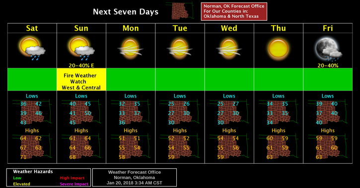
Here is your forecast from the NWS/NORMAN along with the watch info for SUNDAY;
Today-Partly sunny, with a high near 63. South wind 11 to 14 mph, with gusts as high as 20 mph.
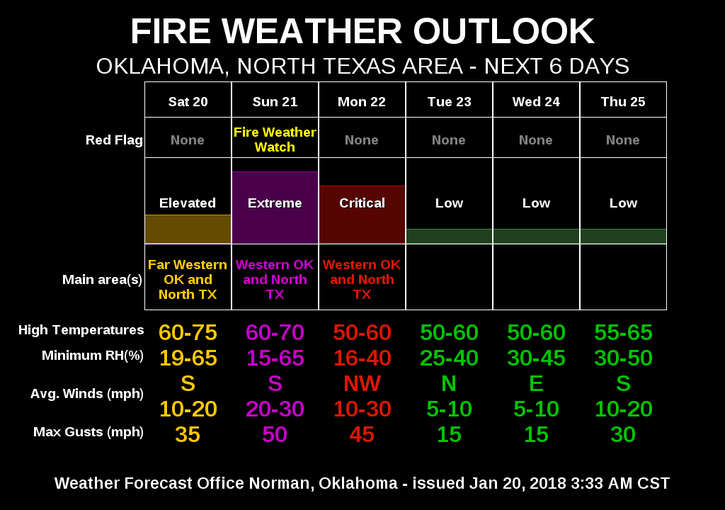
…FIRE WEATHER WATCH REMAINS IN EFFECT FOR SUNDAY FOR BREEZY
WINDS AND LOW RELATIVE HUMIDITY FOR THE WESTERN HALF OF OKLAHOMA
AND ALL OF WESTERN NORTH TEXAS…
* WINDS…Southwest to west 20 to 30 mph with gusts up to 45 mph.
* RELATIVE HUMIDITY…As low as 14 percent.
* TEMPERATURE…Highs 55 to 70 degrees F.
* IMPACTS…Fires that develop will likely spread rapidly. Outdoor
burning is strongly discouraged.
PRECAUTIONARY/PREPAREDNESS ACTIONS…
A Fire Weather Watch means that critical fire weather conditions
are forecast to occur. Listen for later forecasts and possible RED FLAG WARNINGS.
HAVE A GREAT DAY!!
MIKE