0257L-SATURDAY OUTLOOK FROM GARFIELD COUNTY EMERGENCY MANAGEMENT-9/16/23
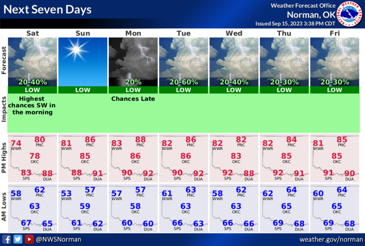
* Today, we’ll have a chance for lite showers early then the sun comes back out during the day through a good part of Monday. Starting Monday evening, or so, a percent of rain or storms comes into play anywhere from 20 to 50% through the rest of the week. This said, high temps this week shouldn’t get out of the 80s and lows should average between the mid-50s and mid-60s. Winds will increase on Monday and wind gusts will be around 20-25 mph. Fall is almost here and once again it’s time to really look over the home and see what you may need to do to seal off drafty areas. It’s too late when freezing temps arrive, at least outside.
*Weather-wise, we’ll be ok so here is your forecast from the NWS/NORMAN:
Today- Mostly cloudy with a chance of showers after midnight, then partly sunny with scattered showers with isolated thunderstorms this morning. Mostly sunny this afternoon. Highs in the upper 70s. North winds 5 to 10 mph. Chance of rain 50 percent.
Tonight- Mostly clear. Lows in the upper 50s. West winds around 5 mph.
*In this paragraph, since we are in Preparedness Month, many folks don’t feel they need to do anything to get ready for winter or a possible event, even though in the back of their minds they should. Main reason is that nothing major has happened to them. IT WILL at some point and then they will understand the importance. For those of us that have experienced major events, preparedness has a new meaning and that stays with us the rest of our lives. Listen to wisdom as that just might save you a lot of grief at some point in your life. EXPERIENCE =WISDOM.
HAVE A GOOD DAY!