0330L-THURSDAY OUTLOOK FROM GARFIELD COUNTY EMERGENCY MANAGEMENT-12/23/21
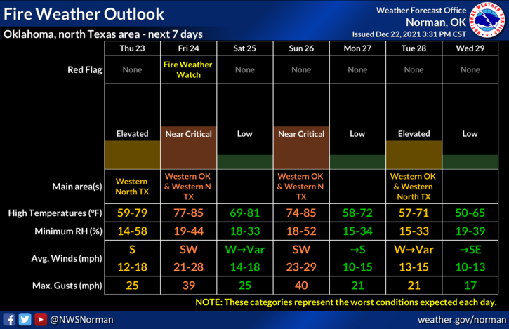
1-Warm temps will continue through CHRISTMAS weekend and as it appears through most of next week. There will be several fronts move through the area causing temps to fall some but even those lower high temps will be higher than what is considered normal. Hopefully, that makes sense.
2- Winds along with lower humidity will also cause the fire danger to go up and down. My opinion on the Fire Danger is EVERYTHING is dry, foliage is dead, humidity will be low, and the winds will blow which equals critical fire weather conditions. On days that forecasted winds may exceed 15 mph, please don’t plan any burning. If you spot smoke and or fire, call 911 so the proper agencies can be dispatched.
3- Overall, we’ll be ok and even with a holiday weekend coming up, don’t let your guard down for a second if you are in a crowd. Situational awareness as has been discussed in the past is extremely important so stay aware of what’s happening around you. Some people out there wait for the holidays so they so they can wreck yours so pay attention to your surroundings.
4- Here is your forecast from the NWS/NORMAN;
Today-Partly cloudy. Areas of fog in the morning. Highs in the lower 60s. South winds 10 to 15 mph.
Tonight-Mostly clear. Lows in the lower 40s. South winds 10 to 15 mph.
STAY SAFE!