0320L-THURSDAY UPDATE FROM ENID/GARFIELD COUNTY EMERGENCY MANAGEMENT-3/29/18
1- The rains came early this morning and they came hard. The lightning was intense. Radar indicated rainfall is between 1 and 2 inches in areas around the county so far at 0255L. Let me know your rainfall totals when these storms move out. There is still some lightning in the area so wait until that subsides. Totals are not as important as your lives are.
2-There may be some more showers this morning so just enjoy the rain. A cold front will push through today bringing in cooler air and north winds. You may want to put a jacket in the car just in case along with that umbrella.
3-We may see some sunshine as we did yesterday after the front pushes through the area. At least the air will be fresh and clean for a while. Overall, we’ll be ok.
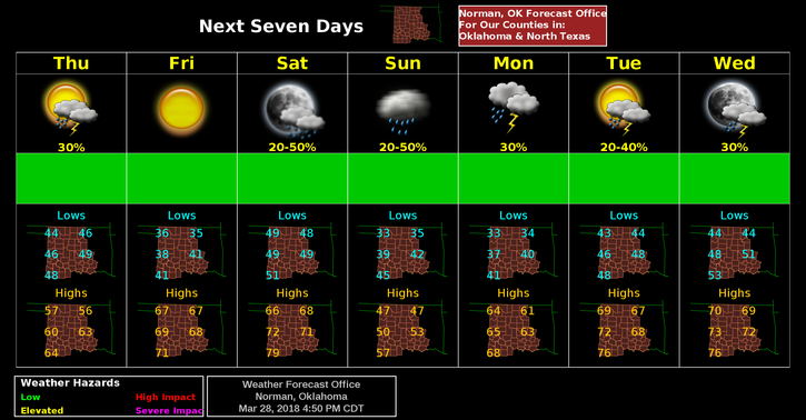
4- Here is your forecast from the NWS/NORMAN;
Thursday-Showers likely and possibly a thunderstorm before 7am. Between 7 am and 1 pm, a slight chance of showers. After 1 pm- a slight chance of showers and thunderstorms. Partly sunny, with a high near 54. North winds 10 to 20 mph gusting to 25 mph. Chance of precipitation is 60%. New rainfall amounts of less than a tenth of an inch, except higher amounts possible in thunderstorms.
Thursday Night-Partly cloudy, with a low around 35. North wind 5 to 10 mph becoming light after midnight.
5- REMEMBER-send me your rainfall totals and then empty your gauge.
HAVE A SUPER DAY!!
MIKE