FROM GARFIELD COUNTY EMERGENCY MANAGEMENT-THURSDAY-10/19/17
DOWNLOAD OUR EMERGENCY APP-GARFIELD COUNTY EM-IT JUST MIGHT SAVE YOUR LIFE!
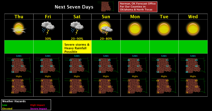
Today’s forecast from the NWS/NORMAN;
Thursday-Sunny with a high near 78. South winds 5 to 15 mph, with gusts as high as 25 mph.
Thursday Night-Partly cloudy with a low around 58. South southeast winds around 10 mph.
The next few days look warm and windy. Saturday afternoon into the evening hours look a little touchy. We are in an ENHANCED AND SLIGHT RISK AREA for severe weather on SATURDAY. Timing appears to be late afternoon into the evening hours. Main threats are winds and hail as a squall line moves through the area. All of this is associated with a cold front that will push through during that this timeframe. More details tomorrow as the lines on the graph below will change as the forecast verifies. We’ll be ok.
HAVE A GREAT DAY!!
MIKE