0415L-TUESDAY OUTLOOK & INFO FROM GARFIELD COUNTY EMERGENCY MGMT-4/14/2020
FREEZE WARNING IN EFFECT UNTIL 9AM THIS MORNING.
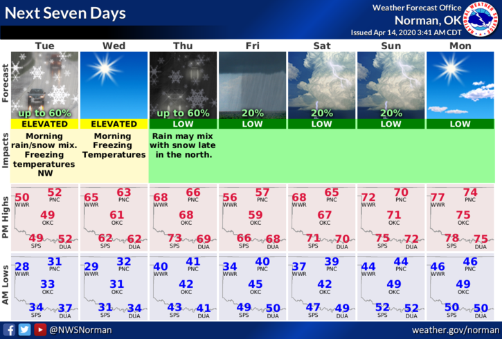
1- There is a slight chance to see a snow flurry this morning but if any do fall, it would only be a trace. This said the only for sure thing this morning is the cold temps. We should bottom out temp-wise around 30-32 degrees this morning give or take. That said, we’ll warm up some Wednesday into Thursday then another cold front with some sort of precip will occur then we should warm back up a little over the weekend.
2-STORM SEASON in Oklahoma begins January 1st and ends December 31st. The more intensive storms usually occur in Late April through May into at least mid-June. ANYTIME conditions are just right, bad things can happen, thus our year long storm season. Being prepared is EXTREMELY IMPORTANT so you don’t panic while watching the drama on TV. Understanding the basic weather patterns and what actually happens in this part of the world is important so you can make good decisions even under pressure without letting your emotions get out of control. If you are new to the area, number 1-download our GARFIELD COUNTY EM app. Number 2- download our Preparedness Guide here- https://gcem.org/wp-content/uploads/2019/05/FamilyPreparednessGuide2019.pdf Take the time to actually read this and if you have questions, contact us an we’ll get your questions answered.
3- Here is your forecast from the NWS/NORMAN;
Today-Decreasing clouds with a slight chance of rain and snow early in the morning, then a slight chance of rain late in the morning. Highs in the lower 50s. Light and variable winds becoming southwest around 10 mph in the afternoon. Chance of precipitation 20 percent.
Tonight-Clear with lows around 30. Southwest winds around 10 mph.
HAVE A GREAT DAY!!
MIKE