0400L-TUESDAY OUTLOOK FROM GARFIELD COUNTY EMERGENCY MANAGEMENT-4/16/19
ADVISORY FOLKS- WE HAD SEVERAL FIRES THAT STARTED IN DITCHES YESTERDAY. PLEASE DO NOT THROW CIGARETTE BUTTS OUT OF YOUR WINDOWS!! Also, if you see suspicious activity, contact 911. The FIRE DANGER is increasing so please help us in this respect. We have several areas around the county that if they were to catch fire, we have no choice but to let it burn. That could put homes in danger downwind. We can’t get equipment into some of those areas safely due to terrain and canyons. We don’t want to lose any firefighters or equipment. Be extremely careful and if you see smoke or fire, call 911 immediately.
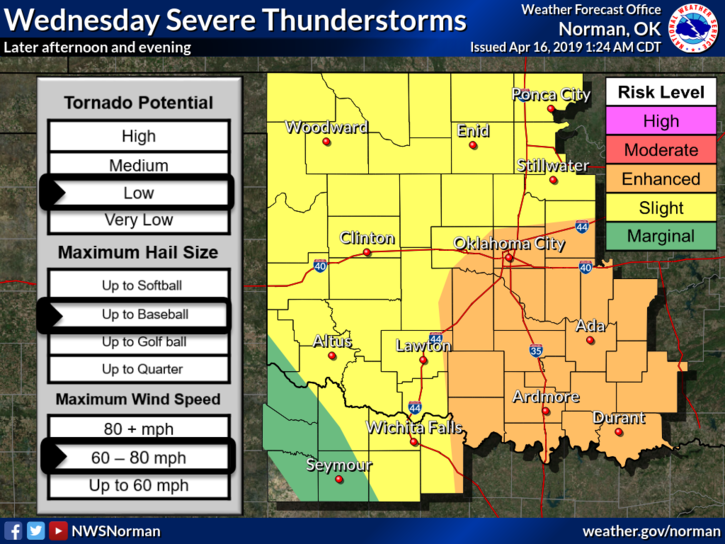
2- Weatherwise for today, warm and windy once again so be careful while driving the open roads. Wednesday, we’ll have a slight risk for severe weather. There are still questions where everything will come together but if we see storms, high winds and hail will be our main threats with a very small chance of seeing swirly things around the region. AGAIN, NOTHING IS SET IN STONE YET. I’ll advise this evening as forecasts verify and/or change.
3- Here is your forecast from the NWS/NORMAN;
Tuesday-Partly sunny, with a high near 77. South southwest wind 16 to 22 mph, with gusts as high as 31 mph.
Tuesday Night-Mostly cloudy, with a low around 63. South wind 18 to 24 mph, with gusts as high as 33 mph.
HAVE A GREAT DAY!!
MIKE