0420L-TUESDAY UPDATE FROM ENID/GARFIELD COUNTY EMERGENCY MANAGEMENT-4/17/18
1- LT. GOVERNOR TODD LAMB EXTENDED THE “BURN” BAN TO INCLUDE AN ADDITIONAL 36 COUNTIES. GARFIELD COUNTY IS ONE OF THEM. NO OUTDOOR BURNING OF ANY KIND IS ALLOWED.
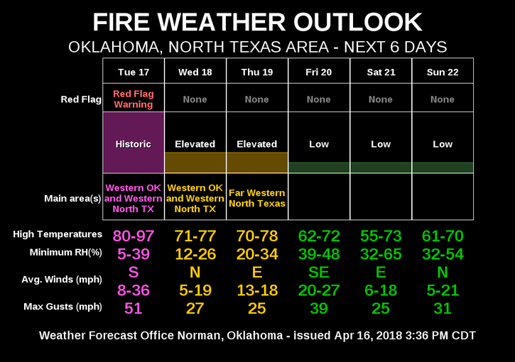
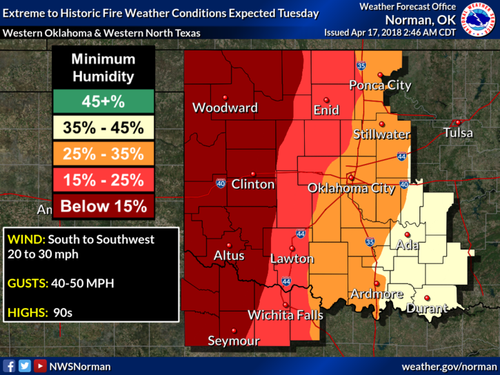
2- RED FLAG FIRE WARNING IN EFFECT JUST TO OUR WEST. Depending on what happens with the dryline today in our area will depend on whether we get added to the Red Flag Warning. You can read the discussion here: https://forecast.weather.gov/product.php?site=NWS&issuedby=OUN&product=AFD
3- I understand that many are tired of fire, fire, fire. We are experiencing very dangerous drought conditions and if we don’t receive substantial RAINFALL to green things up, it’s only going to get worse, ESPECIALLY AS THE WHEAT RIPENS. 1 or 2 inches of rain won’t make much difference if it comes fast. Overall, please be vigilant in keeping an eye out for smoke and fire remembering that it is now ILLEGAL to burn in a BURN BAN.
4-Rain chances daytime Friday per guidance are 15-25% increasing to 60-80% Friday night. We can only hope it does occur.
5-Our TASK FORCES are on stand-by for possible deployment. Team 2 will be 1st in line. We’ll advise on that if deployment occurs. The Task Force Coordinator and I will discuss once again deployment strategy if needed. FOR OUR TASK FORCES- THERE WILL BE AN UPDATE OF WX INFORMATION AND DEPLOYMENT OPTIONS ON THE GCEM GROUP CHANNEL OF THE GARFIELD COUNTY EM APP AROUND 0900L. That channel is exclusive to all emergency services personnel in and around Garfield County.
6-Here is your forecast from the NWS/NORMAN;
Tuesday: Sunny with a high near 88. South wind 15 to 25 mph, with gusts as high as 35 mph.
Tuesday Night: low around 47. South wind 20 to 25 mph becoming north northwest after midnight. Winds could gust as high as 36 mph.
STAY SAFE,
MIKE