0345L-TUESDAY OUTLOOK FROM GARFIELD COUNTY EMERGENCY MANAGEMENT-3/9/21
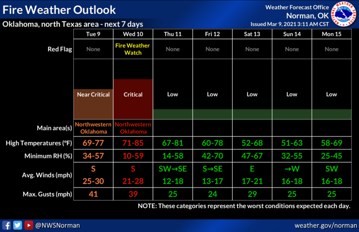
1-WIND ADVISORY in effect from noon today until midnight tonight. Winds 20-30 gusting to 40 mph will be the main issue. Humidity and Dew Point temps will be in the 50s along with air temps in the low 70s.
2- Fire danger will be prevalent around the region so if you see smoke/fire, call 911 so a quick response can be sent. We have had several fires around the county lately so be careful out there. ALSO- NO controlled burning for the next few days in Garfield County please!! Some folks think that they can control fire in 25-35 mph winds, NOPE!! Just wait and burn another day.
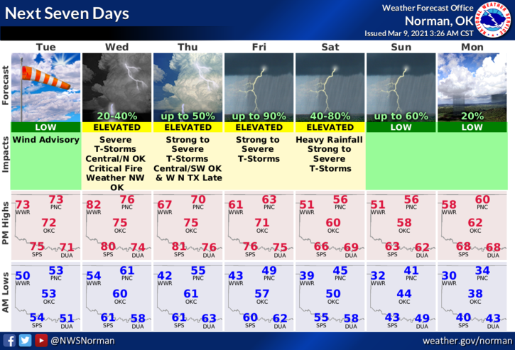
3- Thunderstorms come into the picture late Wednesday through possibly the weekend. Severe storms are possible Wednesday night and again on Friday. We’ll have a strong front push in Thursday dropping our high temps from the 70s into the 60s then into the 50s by the first of next week. These thunderstorms will possibly be our first test of the spring season. As it appears right now, hail and winds will be the main issues.
4- If you don’t have our GARFIELD COUNTY EM app, NOW IS THE TIME to get it downloaded. You’ll receive information directly from the NWS and GCEM during severe weather events. You never know, it just might save your life and it will mostly give you peace of mind.
5- Here is your forecast from the NWS/NORMAN;
Today-Partly cloudy then becoming mostly cloudy early in the afternoon then becoming partly cloudy. Windy. Highs in the lower 70s. South winds 20 to 30 mph increasing to 25 to 35 mph in the afternoon.
Tonight-Mostly cloudy. Lows around 60. South winds 20 to 25 mph.
HAVE A GOOD DAY!!