0415L-WEDNESDAY UPDATE FROM ENID/GARFIELD COUNTY EMERGENCY MANAGEMENT-4/4/18
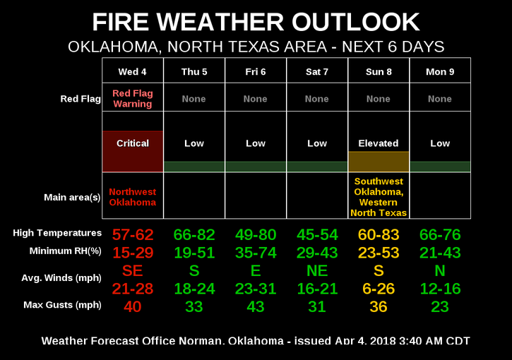
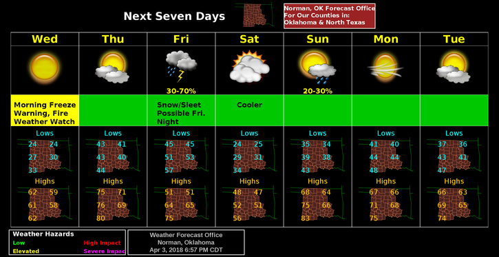
1- FREEZE WARNING UNTIL 10 AM THIS MORNING. ELEVATED FIRE WEATHER CONDITIONS TODAY.
2- Warmer today and Thursday then another front to cool things down. Chance for thunderstorms on Friday. We’ll see how that pans out. Overall, we’ll be ok.
3- MANY of you message me on messenger and get upset because I don’t reply. Messenger doesn’t work for me half the time and I am not on Facebook all day long. I am only on social media maybe twice a day, if that. Many of you state you have been hacked. I am receiving upwards of 12 videos a day from alleged friends and I won’t open these videos. I don’t need the adware and viruses that come with those. It’s the same in email. I won’t open attachments UNLESS you contact me by voice and let me know it’s coming. Call me old fashion, but I have lost computers due to viruses and it’s getting worse out there. Just contact me and I will respond. So if you need to contact me, email me mike@gcem.org or call me 580-541-1263.
4- Here is the forecast from the NWS/NORMAN;
Wednesday-Sunny, with a high near 59. Light and variable wind becoming south 10 to 15 mph in the morning. Winds could gust as high as 21 mph.
Wednesday Night-Increasing clouds, with a low around 42. South wind 9 to 15 mph, with gusts as high as 23 mph.
5- Now is a great time to download our GARFIELD COUNTY EM app. You’ll need this as storm season gets ramped up.
HAVE A GREAT DAY!!
MIKE