0405L-WEDNESDAY OUTLOOK FROM GARFIELD COUNTY EMERGENCY MANAGEMENT-6/23/21
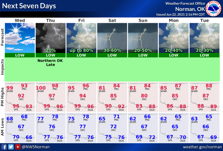
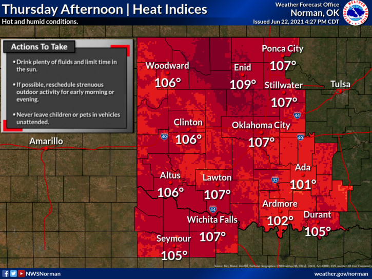
1- The heat is back on once again and the HEAT INDEX is back in play. Instead of preaching the heat issue, everyone should know what to do. Main thing is stay hydrated! On Thursday, dangerous heat index temps could reach 109 degrees per guidance. We have a thin stream of moisture moving back into the area and it’s going to be humid. Rain “chances” come back into the area Thursday evening through the weekend. Here is your forecast from the NWS/NORMAN;
Wednesday-Mostly cloudy, then gradually becoming sunny and hot, with a high near 99. Heat index values as high as 103. South wind 15 to 25 mph, with gusts as high as 30 mph.
Wednesday Night-Partly cloudy, with a low around 76. South wind 15 to 25 mph, with gusts as high as 30 mph.
2- The FIRE DANGER is increasing even though we are facing high heat index temps. We are dry but the winds are not in our favor. Folks have been really good to call 911 immediately after a fire has been discovered and response has been pretty quick. We do have a FIRE STARTER out there so keep your eyes peeled and if you notice suspicious activity, call 911 immediately.
Overall, we’ll be ok but pay close attention to yourself and others if working outdoors and keep an eye out for smoke and/or fire. Be sure to download our GARFIELD COUNTY EM app, it just could save your life.
HAVE A GOOD DAY!!
MIKE