FROM GARFIELD COUNTY EMERGENCY MANAGEMENT
DOWNLOAD OUR EMERGENCY APP—GARFIELD COUNTY EM—IT JUST MAY SAVE YOUR LIFE!
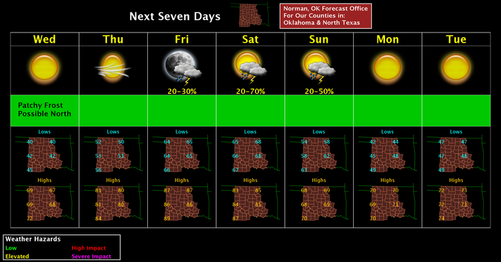
Today will be a VERY nice day after a chilly start. Light winds and temps in the upper 60’s. I know many aren’t ready for colder weather but there is hope for you folks. Temps THURSDAY through SATURDAY will be in the low to mid 80’s THEN there is a MARGINAL risk for severe weather here in our neck of the woods late on Saturday then temps fall back into the upper 60’s to low 70’s next week.
As stated yesterday, the Vance WSR 88D Radar is down for upgrades and hopefully will be back up on Friday. Don’t worry; we still have good radar coverage from 4 surrounding government radars.
Here is your forecast from the NWS/NORMAN;
Wednesday-Sunny, with a high near 67. Calm wind becoming south southeast 5 to 10 mph in the afternoon.
Wednesday Night-Mostly clear, with a low around 51. South southeast wind around 10 mph.
HAVE A SUPER DAY!!
MIKE