0325L-WEDNESDAY OUTLOOK FROM GARFIELD COUNTY EMERGENCY MANAGEMENT-8/23/23
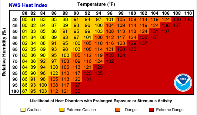
*HEAT ADVISORY today and Thursday from noon until 9pm. Our heat index max today is expected around 104. This could change and if it does, a warning will be issued.
* What’s the difference between an Excessive Heat Warning and Heat Advisory?
An Excessive Heat Warning is issued when the heat index value is expected to reach or exceed 110 degrees. A Heat Advisory is issued when the heat index value is expected to reach 105 to 109 degrees. Either way, it’s hot out there so use EXTREME CAUTION while doing anything outdoors.
*Overall, we’ll be ok, so here is your forecast from the NWS/NORMAN;
Today- Mostly sunny. Highs in the upper 90s. South winds 5 to 10 mph. Heat index values up to 107.
Tonight- Partly cloudy in the evening, then clearing. Humid with lows in the mid-70s. South winds 5 to 10 mph. Heat index values up to 106 early in the evening.
* Fire Danger is increasing. If you see smoke or fire, call 9-1-1.
*This post can be found under GCEM Blog on the GARFIELD COUNTY EM app. It can also be found on the front page of our website at https://gcem.org
HAVE A GOOD DAY!