0312L-FRIDAY OUTLOOK FROM GARFIELD COUNTY EMERGENCY MANAGEMENT-2/18/22
NOTE: There is a chance we “may” see some below normal temps next week along with possibly more snow by mid to late week. We’ll see how that mess comes together.
1- The snow yesterday gave us a taste of what whiteout conditions are all about. Most of that didn’t last too long but imagine living in Alaska and dealing with these type conditions most of the winter. We received approximately 2 inches of snow that was measurable. That said, if we could ever have a snowstorm with light winds, we would actually be able to measure snow depth a lot better. High winds don’t allow anything accurate when measuring snow depth and drifts don’t count. The only other report that was called in to me was at Hillsdale with approximately 4 to 5 inches.
2- We did receive anywhere from ¼ to ½ inch of rainfall prior to the snow so that MIGHT help us drought-wise but probably not much. One thing to keep in mind, if this type of storm system, atmospherically, had come through in the mid to late spring, we would have had some major severe weather. The parameters would be instability, windshear, cold air from the north, warmer and dryer air from the southwest, and warm moist air from the gulf. You have these things in place, it just might be a rough afternoon and evening.
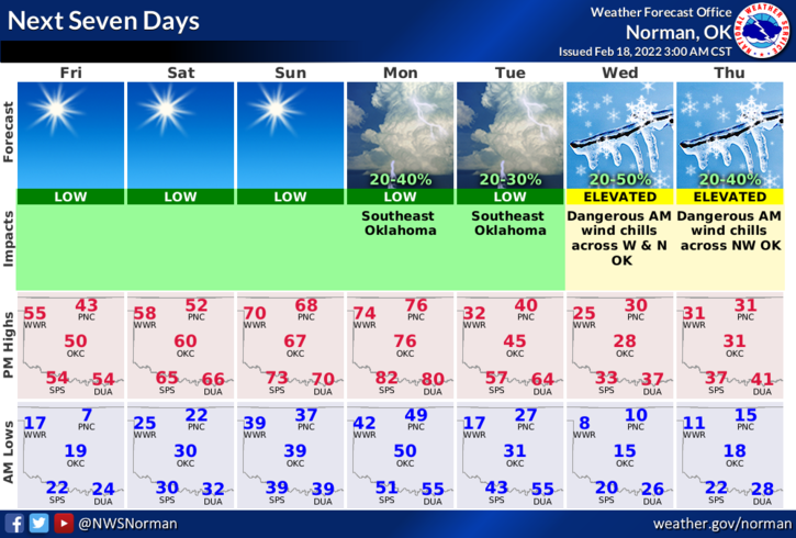
3- Overall, we survived. That’s a good thing. Here is your forecast from the NWS/NORMAN;
Today-Sunny. Not as cool. Highs in the upper 40s. South winds around 10 mph.
Tonight-Clear. Not as cold. Lows in the lower 20s. Southwest winds around 10 mph shifting to the west after midnight.
STAY SAFE AND ENJOY THE WARMER WEATHER.