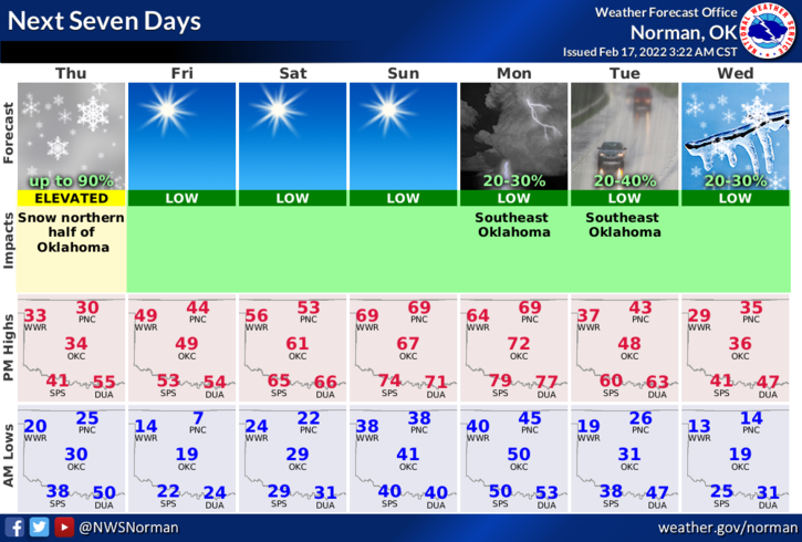
THURSDAY OUTLOOK FROM GARFIELD COUNTY EMERGENCY MANAGEMENT-2/17/22
1- WINTER STORM WARNING in effect until 6pm tonight. Light ice accumulation this morning with snow accumulations of 2 to 6 inches and possibly more by later today. Wind gusts upwards of 45 mph are possible.
2- At 0310 local time, we are receiving light freezing rain and strong northerly winds. We have reached 32 degrees so as the atmosphere cools, we will start to see a changeover to some freezing precipitation and then snow. Snow totals will be difficult to measure due to the winds. We are expecting 2 to 5 inches of snow but if we have any heavier snowbands move through the area, that total could increase significantly.
3- We have already hit our high temperature for today so it’s downhill from here. Driving might be treacherous as we will have ice on the ground due to the rain and now freezing rain so SLOW DOWN and drive carefully. Winds COULD wreak havoc on power lines if we continue to receive the freezing rain. Hopefully the transition to snow will occur shortly.
4- Overall, we should be ok so slow down and drive carefully and we’ll get through this mess as we always do. Here is your forecast from the NWS/NORMAN;
Today- Windy. Much colder. Snow showers, sleet, freezing rain and a slight chance of thunderstorms early in the morning. Snow late in the morning, then a slight chance of snow and freezing rain early in the afternoon. Patchy blowing snow through the day. Highs in the upper 20s. North winds 25 to 30 mph decreasing to 15 to 25 mph in the afternoon.
Tonight-Clear, colder. Lows around 8. Northwest winds around 10 mph in the evening becoming light and variable.
STAY WARM AND SAFE