FROM GARFIELD COUNTY EMERGENCY MANAGEMENT-FRIDAY, 1/13/17
GOOD MORNING,
ICE STORM WARNING REMAINS IN EFFECT UNTIL 6 AM CST SUNDAY
TIMING…EARLY FRIDAY MORNING THROUGH EARLY SUNDAY. ICE ACCUMULATIONS MAY EXCEED ONE-HALF INCH IN SOME AREAS.
THE HEAVIEST ACCUMULATIONS ARE EXPECTED “SATURDAY”.
WINDS-NORTH AROUND 10 MPH
That said, there are areas of “scattered” precipitation forming in southeast Garfield County and southeast of the county as of 0545 this morning. As long as it remains scattered, we will fare better at least early. If you wake up to dry conditions, be happy, it will change. The rain will gradually spread throughout the area as the day moves along. We are expecting the heavier rain later today, tonight through Saturday. This will be the timeframe we possibly will see any damage starting to occur due to freezing rain. We’ll wait and see.
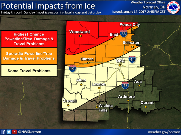
The best thing I have seen this morning is a graph that shows a lesser area of coverage for possible damage from the forecast freezing rain. We’ll see what happens. Just keep in mind we will be below freezing through early Sunday. When rain starts to fall, the ground will become slick. Be very careful out there.
Here is the link to ROAD CONDITIONS-THIS IS A WEIRD SITE that you have to figure out. Good luck.
http://ok.maps.arcgis.com/apps/Viewer/index.html?appid=0143260acf004177935589ab7e2f42c1
Here is the link for OGE www.oge.com/systemwatch
Here is your forecast from the NWS/NORMAN ;
Friday-Chance of freezing rain. Cloudy, with a high near 28. North northeast wind 8 to 10 mph. Chance of precipitation is 50%.
Friday Night-Freezing rain likely. Cloudy, with a low around 27. North wind around 8 mph. Chance of precipitation is 70%.
I will update with a video if necessary later this morning.
Have a great day and be extremely careful when the rain begins.
MIKE