0320L-FRIDAY OUTLOOK FROM GARFIELD COUNTY EMERGENCY MANAGEMENT-1/15/21
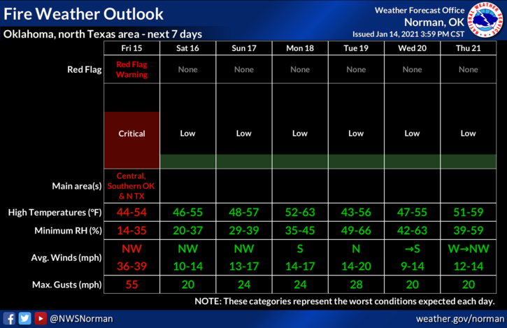
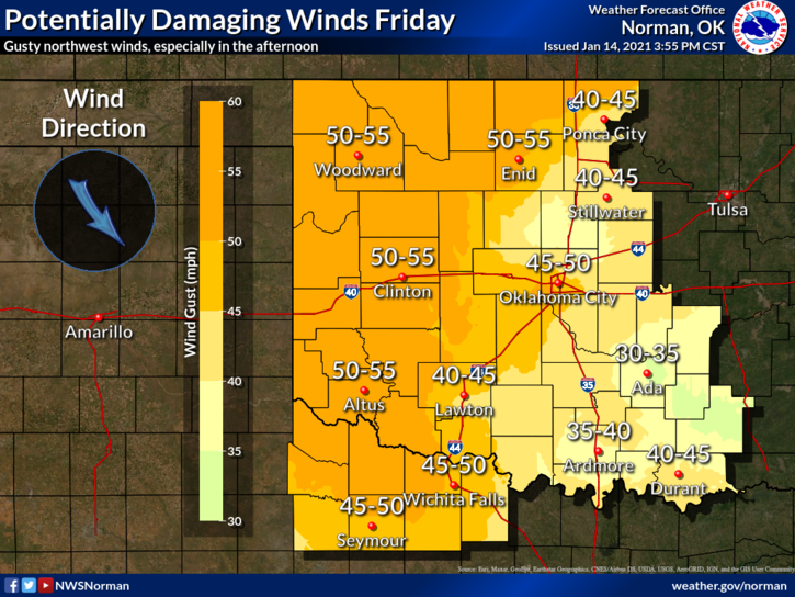
1- A WIND ADVISORY IS IN EFFECT FROM 6 AM THIS MORNING UNTIL 6 PM TONIGHT. WINDS 30-40 MPH WITH SOME GUSTS UPWARDS OF 50-55 MPH ARE POSSIBLE. The Fire Danger will be near the critical area today so remember to keep your eyes peeled and call 911 if you see smoke or fire.
2- Yesterday’s post over our GARFIELD COUNTY EM app to the Public and Fire Commands will be modified and sent out this morning sometime after 7am. Some information has changed so I will get that out after I get back to the office.
3-As stated yesterday, use caution while driving especially on east/west roads and keep an eye out for whipping powerlines. One other thing I didn’t mention yesterday, keep an eye out for trucks or any vehicle that may be dragging a chain causing sparks. These folks can start fires for miles at a time and not realize it until they are stopped. Just remember that YOU can help stop wildland fires by staying aware.
4-Overall, we’ll be ok so here is your forecast from the NWS/NORMAN;
Friday-Mostly sunny, with a high near 45. Windy, with a northwest wind 25 to 30 mph increasing to 35 to 40 mph. Winds could gust as high as 55 mph.
Friday Night-Clear with a low around 26. North northwest wind 10 to 20 mph, with gusts as high as 28 mph.
HAVE A GOOD DAY.
MIKE