0310L-FRIDAY OUTLOOK FROM GARFIELD COUNTY EMERGENCY MANAGEMENT-10/14/22
GARFIELD COUNTY EM is our notification app. Download it, play with it, and learn it. Now you’re prepared for whatever mother nature and others could throw at you.
1-First freeze of the year may come Tuesday or Wednesday morning as colder air filters in from a surface high that will settle into the area. If we don’t hit 32 degrees, we’ll be close. If I was guessing, based on guidance, I would say we will be close. We’ll see what happens. Rain is still in the forecast for this weekend so we’ll hope it occurs here. We’ll see!
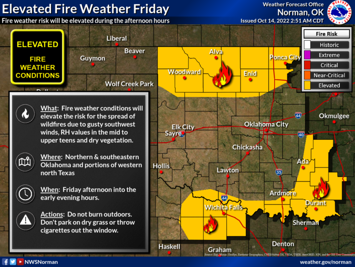
2- FIRE WEATHER will continue for today. Here is a FIRE DANGER STATEMENT FROM THE NWS:
ELEVATED FIRE WEATHER CONDITIONS EXPECTED…AFFECTED AREA…PORTIONS OF NORTHERN, CENTRAL, AND SOUTHEAST OKLAHOMA. * WINDS…WEST TO SOUTHWEST WINDS 10 TO 20 MPH WITH GUSTS OF 25 MPH.* RELATIVE HUMIDITY…AFTERNOON HUMIDITY OF 15 TO 20 PERCENT. * TEMPERATURES…HIGHS 83 TO 88. * TIMING.NOON TO 7 PM.
3- Per number 2 above, keep an eye out as we had a fire Northwest of Kremlin yesterday afternoon and it could have been arson. We’re still looking into it. Stay alert and report suspicious activity to the Sheriff’s office or 911. Also, call 911 in the event you see smoke or fire.
4- Overall, we’ll be ok so here is your forecast from the NWS/NORMAN;
Today- Sunny. Highs in the mid-80s. West winds 15 to 20 mph with gusts up to 30 mph.
Tonight- Clear. Lows around 50. Southwest winds 10 to 15 mph with gusts up to 25 mph, becoming north 5 to 10 mph after midnight.
HAVE A GOOD DAY!