FROM GARFIELD COUNTY EMERGENCY MANAGEMENT-MONDAY 8/14/17
DOWNLOAD OUR EMERGENCY APP-“GARFIELD COUNTY EM“, IT JUST MIGHT SAVE YOUR LIFE!!
Today’s information:
Many folks have asked me if we will warm back up. That answer is YES!! We are having a cooler start to August but it has happened before. All I can say is enjoy this cooler weather while you can. Believe me, we will get back to normal soon.
Since it has been cooler, many folks are outside for longer periods of time and therefore may get into areas that are tick infested or into creek areas where poison oak and ivy are present. If you all are out and about especially in the woods, make sure you check yourself, the kids, and the pets for ticks and see if anyone is itching badly. These can be a bit rough on the family so just be observant. If you are traveling, say on vacation, maintain a higher level of awareness as you aren’t that familiar with the areas that you may be visiting. OK, No more preaching.
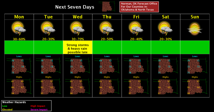
That said, here is your forecast from the NWS/NORMAN:
Monday-50 percent chance of showers and thunderstorms, mainly before 1pm. Mostly cloudy, with a high near 88. South southeast wind 6 to 9 mph. New rainfall amounts of less than a tenth of an inch, except higher amounts possible in thunderstorms.
Monday Night-30 percent chance of showers and thunderstorms. Mostly cloudy, with a low around 72. South southeast wind 7 to 9 mph.
HAVE A SUPER DAY!!
MIKE