0330L-MONDAY OUTLOOK FROM GARFIELD COUNTY EMERGENCY MANAGEMENT-2/8/21
REMEMBER THAT YOU CAN GET INFORMATION FROM OGE, ROAD CONDITIONS, ETC ON OUR GCEM.ORG WEBSITE. Scroll down a little on the front page and there you go!
1- “WINTER WEATHER ADVISORY” remains in effect until 4pm today. All surfaces will be affected by freezing fog/drizzle and/or freezing rain. Use “EXTREME CAUTION” if you have to get out today.
2- After this system moves out, another shot of reinforcing arctic air will push in and keep us in the deep freeze until at least Saturday. WIND AND WIND CHILL will affect everything out there especially you and your skin. Wear proper clothing and cover as much skin as possible. If you have outdoor pets or other animals, check on them frequently and make sure they have water/food and of course some sort of shelter.
3- OVERALL, we are going to be bitter cold compared to what we are actually used to so take the proper precautions to protect yourselves, your kids, and your pets.
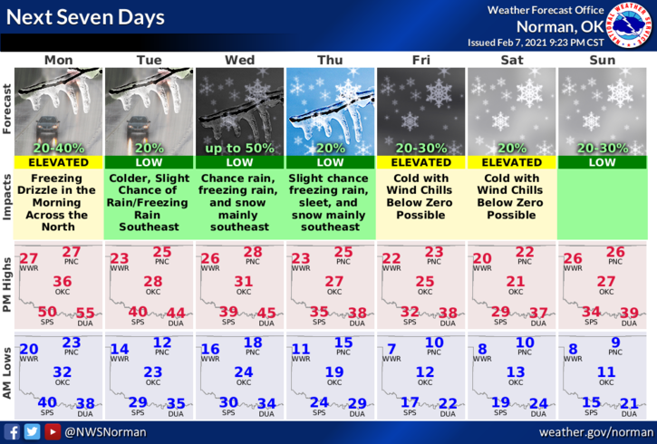
4- Here is your forecast from the NWS/NORMAN;
Today- Cloudy with a 40% chance of light freezing fog/freezing rain/and light freezing drizzle in the morning and afternoon. Highs in the mid-20s. North winds 10 to 15 mph gusting to 20 mph.
Tonight-Cloudy. Lows around 17. North winds 10 to 15 mph.
STAY WARM!
MIKE