0400L-TUESDAY OUTLOOK FROM GARFIELD COUNTY EMERGENCY MANAGEMENT-2/9/21
1- GARFIELD COUNTY EM is our emergency/notification app. If you don’t have it, you will probably need it in the very near future. Download it, learn it, and stay prepared. Your life could depend on it.
2- How does everyone like being in the freezer? Get used to it this week as there is no relief in sight right now through at least next Tuesday, maybe longer next week. Here is a link to COLD WEATHER PREPAREDNESS- https://www.weather.gov/safety/cold I would highly recommend that everyone re-brief yourselves on this as the cold we are experiencing can be deadly if you aren’t careful. The wind chill chart is located where the link will take you.
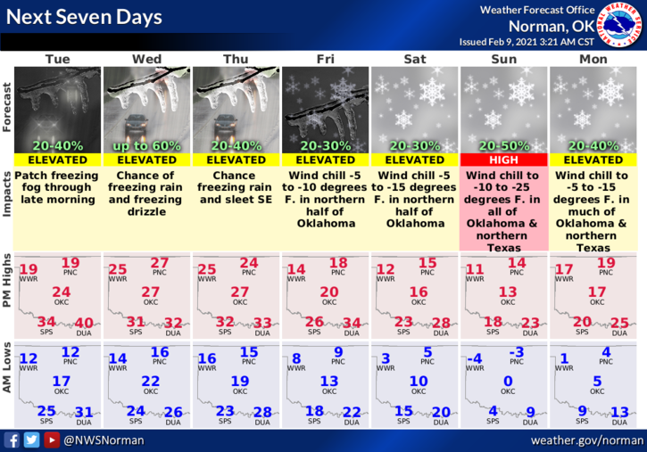
3- LOCALLY; all I can say is travel will be dangerous on the roads so slow down. Air temperature will be in the upper teens to low 20s so cover up. PLEASE DON’T text and drive as you WON’T be able to stop when you realize you’re going to collide with something or someone. Overall, WALK CAREFULLY. Here is your forecast from the NWS/NORMAN;
Today-Cloudy. Patchy freezing fog in the morning. Highs in the lower 20s. North winds 10 to 15 mph WITH HIGHER GUSTS
Tonight-Mostly cloudy. Areas of light freezing drizzle after midnight. Lows around 14. Northeast winds 10 to 15 mph.
Stay warm and cover up.
Mike