0355L-MONDAY OUTLOOK FROM GARFIELD COUNTY EMERGENCY MANAGEMENT-1/28/19
1) A FRONT will push into the area and cool us down during the day. I hope you enjoyed the warmth this past weekend. Winds will be an issue with some gusts possibly to 35mph +.
2) Just remember, it’s still winter and as these systems move across the area, we will experience some sort of winter precip. Many folks ask whether we will see any measurable snow this year and my answer is MAYBE!! We still have February and March to go so maybe we’ll get lucky!! Keep a coat handy in your vehicle.
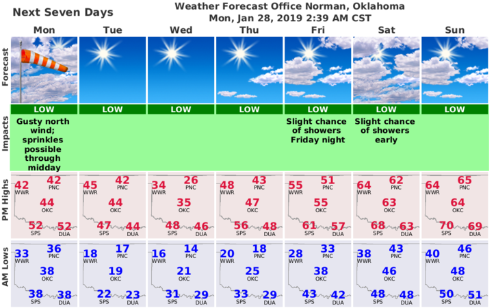
3) Here is your forecast from the NWS/NORMAN;
Monday- A slight chance of sprinkles before noon. Highs in the mid 40’s. Cloudy, then gradually becoming mostly sunny, with a temperature falling to around 36 by 5pm. Windy, with a north wind 11 to 16 mph increasing to 20 to 25 mph in the afternoon. Winds could gust as high as 37 mph.
Monday Night-Mostly clear, with a low around 18. North wind 11 to 16 mph becoming light and variable. Winds could gust as high as 24 mph.
FIRE DANGER IS INCREASING. USE EXTREME CAUTION. REPORT ANY SMOKE OR FIRE TO 911.
HAVE A GOOD DAY!!
MIKE