0330L-MONDAY OUTLOOK FROM GARFIELD COUNTY EMERGENCY MANAGEMENT-6/12/23
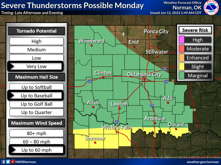
*A quote from the NWS: From the atmosphere that brought you “June in May”, we now present:” May in June”. I thought this to be so true and we had a little bit of July in late April. I think our weather is a bit confused but it should come around in the near future when the oven gets turned back on. With highs today forecast to be in the 70s, we will have rain chances today and everyday this week. We are in a GENERAL and MARGINAL risk area so we’ll see what happens for sure.
* The main area for severe weather later today and tonight looks to be in north Texas and Southern Oklahoma. If you plan on traveling that way, pay exceptional attention to weather conditions. Very large hail and possibly tornadoes are forecast from central Texas up and along the RED RIVER areas. For us, we’ll see how early morning storms track and deal with whatever Mother Nature decides to throw at us.
*OVERALL, we’ll be ok so here is your forecast from the NWS/NORMAN;
Today- Partly sunny with a chance of showers and thunderstorms. Highs in the upper 70s. Northeast winds 5 to 10 mph. Chance of rain 50 percent.
Tonight- Mostly cloudy. A slight chance of showers and thunderstorms in the evening, then a chance of showers and thunderstorms after midnight. Lows in the upper 50s. East winds 5 to 10 mph. Chance of rain 40 percent.
*Be sure to download our GARFIELD COUNTY EM app. You’re NOT PREPARED without it.
HAVE A GOOD DAY!