0410L-MONDAY OUTLOOK FROM GARFIELD COUNTY EMERGENCY MANAGEMENT-5/2/22
“STORM SIREN 3 MINUTE TEST” WILL OCCUR IF THE WEATHER CLEARS AT NOON TODAY. IF IT DOESN’T, WE WILL TRY AGAIN ON TUESDAY.
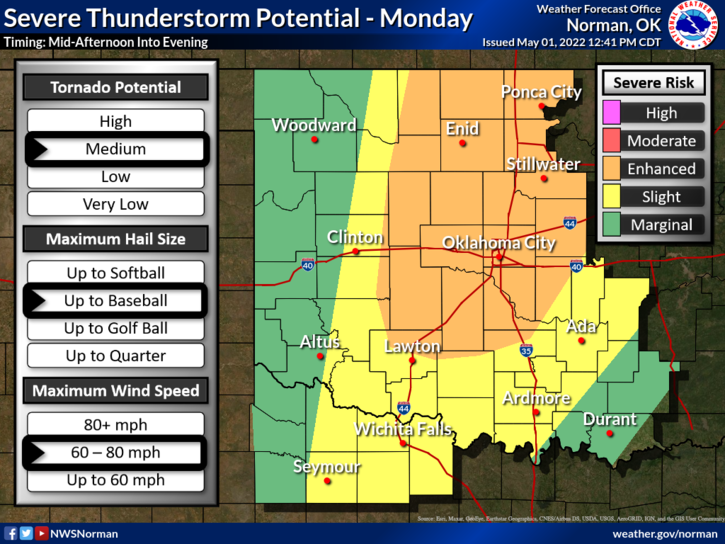
1-ENHANCED RISK for severe weather later today and tonight. ALL HAZARDS will be possible as a warm front, the dryline, and cold front move into and through the area. Exact timing isn’t possible to state as ongoing convection early this morning may change some of the parameters for later today. Where the warm front ends up later today, will be where the most significant severe weather will be. It may end up in southern Kansas. Then we focus on where the dryline is and it looks like it will be somewhere in our area. The cap will be weaker than it was last Friday.
2- All that said, the world won’t come to an end so just make sure you have your severe weather plan ready and keep a very close eye on conditions. Here is your forecast from the NWS/NORMAN;
Today-Mostly cloudy with a chance of thunderstorms. A chance of showers. Highs in the lower 80s. Southeast winds 15 to 20 mph. Gusts up to 35 mph this afternoon. Chance of rain 50 percent.
Tonight-Partly cloudy with a chance of showers and thunderstorms in the evening, then mostly cloudy after midnight. Some thunderstorms may be severe. Less humid with lows in the mid- 40s. Northwest winds 15 to 20 mph with gusts up to 35 mph. Chance of rain 50 percent.
FINALLY, Make sure you have our GARFIELD COUNTY EM app and remember to listen to our LOCAL FM radio stations. I will do a live social media update later this morning or early this afternoon after all the briefing are over with.
NO UPDATED GRAPHICS WERE AVAILABLE AT THE TIME OF THIS POST.
HAVE A GOOD DAY!