0400L-TUESDAY OUTLOOK FROM GARFIELD COUNTY EMERGENCY MANAGEMENT-5/3/22
NO STORM SIREN TEST TODAY, SINCE THEY WERE SET OFF YESTERDAY AFTERNOON.
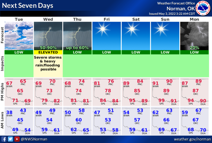
1-Today will be cool and windy. Take some time to get ready for what you weren’t prepared for yesterday and be prepared for tomorrow. We are looking at a similar situation like we had yesterday so prepare accordingly. We will have severe weather with ALL HAZARDS POSSIBLE so just be ready and we’ll see how everything comes together. Overall, we should be ok, maybe some frazzled nerves though.
2-Here is your forecast from the NWS/NORMAN;
Tuesday-Mostly cloudy in the morning, then becoming mostly sunny. Cooler with highs in the mid-60s. North winds 10 to 15 mph, becoming northeast in the afternoon.
Tuesday Night-Mostly cloudy. A slight chance of showers and thunderstorms after midnight. Lows in the upper 40s. East winds 5 to 10 mph. Chance of rain 20 percent.
3- I apologize for the excess movement of my phone while doing the live video yesterday. I don’t have a stand for mounting my phone. As you heard, it can get crazy in the operations room during events like this so thank you for your understanding. After thinking through what happened yesterday, I will most likely go live when tornadic conditions occur so you can keep up with what OUR Spotters are telling us. Suggestions are appreciated. Email me your thoughts on this and we will work out the details. Email mike@gcem.org
4- Reminder- SEVERE WEATHER HAPPENS. We are not immune to it so just understand that whenever it happens, day or night, our first responders/spotter network are out there doing the best they can to gather information for us to give to you so you can make good decisions to keep your families safe.
HAVE A GOOD DAY!