0425L-SATURDAY OUTLOOK & INFO FROM GARFIELD COUNTY EMERGENCY MANAGEMENT-8/24/19
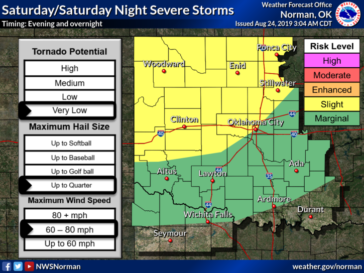
1- SLIGHT RISK FOR SEVERE WEATHER LATER TODAY AND TONIGHT. Large hail, damaging winds, possibly some flooding, and isolated tornadic activity are possible. The tornado threat for us is VERY low but not completely out of the question. Stay weather aware later today.
2-If we go into severe weather operations tonight, I will NOT post on my personal Facebook page but WILL on my emergency management page-@EGCEM as we have time on Facebook. The best way to receive our info and all warnings is on our GARFIELD COUNTY EM app. NWS info comes through automatically and I send info as well. I will do live updates as necessary and I hope my S-10+ phone works properly for this. It has an attitude problem doing live updates.
3- Overall, we’ll be ok but it may be a bit tense as storms approach us later today. If timing changes, we’ll let you know and adjust accordingly. Spotters will be put on standby so just know our network will have eyes on the sky and are prepared just in case.
4- Here is your forecast from the NWS/NORMAN;
Today-Mostly cloudy with a slight chance of thunderstorms. Highs in the upper 80s with southeast winds around 10 mph. Chance of thunderstorms 20 percent.
Tonight- 80% chance for thunderstorms late in the evening, then thunderstorms after midnight. Some thunderstorms may be severe after midnight. Lows in the upper 60s with southeast winds around 10 mph.
WILL ADVISE AS NEEDED.
MIKE