0400L-SATURDAY OUTLOOK FROM GARFIELD COUNTY EMERGENCY MANAGEMENT-12/17/22
1- Cool with WNW winds as we have seen all week. Sunday appears to be a bit warmer but winds will become southerly. Monday, late afternoon, ushers in colder air as a strong cold front moves through the area keeping our high temps in the 30’s and lows in the teens and 20’s. A stronger front moves in Thursday. No need to panic, we can’t stop it so just prepare for it!
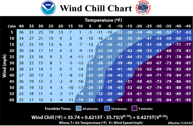
1a- I have had many calls about the weather for the up and coming week. The only thing I can say is, it ISN’T the end of the world. We will be very cold. The one thing everyone should be concerned with is the WIND CHILL. It affects everything and will freeze your skin in a very short time. EXAMPLE- it’s 10 degrees and we have a 10 mph wind. That equals a wind chill temp of -4 degrees. You’ll experience FROSTBITE IN ROUGHLY 30 MINUTES OR SO. It’s extremely painful, based on what folks have told me. Make sure you are covered up when this arctic cold arrives.
2- Overall, we’ll be ok so here is your forecast from the NWS/NORMAN;
Today- Sunny. Highs in the mid-40s. West winds 10 to 15 mph with higher gusts.
Tonight- Clear, cold with lows in the lower 20s. South winds around 5 mph.
3- Be sure and download our GARFIELD COUNTY EM app, You’re not prepared without it.
FINALLY- Dry conditions and winds will increase the fire danger out there so use extreme caution. If you see smoke or fire, call 911. For controlled burns, call 580-234-FIRE (3473).
HAVE A GOOD DAY!