FROM GARFIELD COUNTY EMERGENCY MANAGEMENT
I will keep this in line item format so I don’t write a book, but first, several folks ask about the NOAA ALERTS on the app. You can turn them on and off by tapping the cog in the upper right hand corner of the app. You will see NOTIFICATION SETTINGS. Look for NOAA ALERTS. You can turn them on and off. Your choice. All warnings from the NWS come over this part of the app.
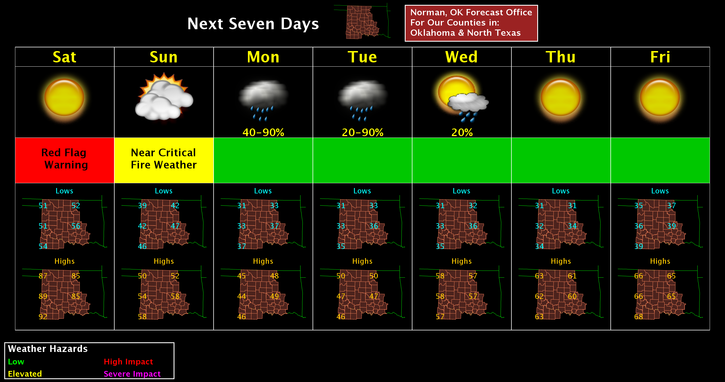
1. RED FLAG FIRE WARNING REMAINS IN EFFECT TODAY FROM 11AM UNTIL 7PM TONIGHT.
2. THE GOVERNOR HAS DECLARED A “BURN BAN” FOR 56 COUNTIES HERE IN OKLAHOMA. CLICK THE LINK TO SEE ALL THE COUNTIES INVOLVED. GARFIELD COUNTY IS IN THIS BAN UNTIL 2/24/17. http://www.forestry.ok.gov/burn-ban-information
3. REPORT ANY SMOKE OR FIRE THAT YOU MAY SEE. KEEP IN MIND THAT YOU MAY SEE SMOKE FROM FIRES SOUTH OF US FROM 30-60 MILES AWAY. THAT WAS THE CASE YESTERDAY.
4. A cold front will move in later today shifting the winds from the NNW and cooling us back down into the 50’s for Sunday. For today, just be careful and stay alert. Don’t get sunburned too badly.
5. All Garfield County Fire Departments are on stand-by along with our County Task Force in the event we need to assist other counties with fire suppression.
6. Here is your forecast from the NWS/NORMAN;
Saturday- Sunny with a high near 85. South southwest winds 10-20 mph becoming west northwest later in the afternoon.
Saturday Night-Partly cloudy, with a low around 40. North wind 9 to 14 mph increasing to 16 to 21 mph after midnight. Winds could gust as high as 29 mph.
Sunday-Mostly sunny with a high near 51. North wind 15 to 23 mph, with gusts as high as 32 mph.
STAY SAFE AND HAVE A GREAT DAY!
MIKE