0415L-SATURDAY OUTLOOK FROM GARFIELD COUNTY EMERGENCY MGMT-2/22/2020
1- Another nice day with some wind but a little warmer. Clouds will push back in later giving us a chance for rain late tonight into Sunday.
2- There are several variables that could occur over the next 3-5 days. Temps will play a big role in what may happen. If ANY snow occurs, it will most likely be during the overnight hours as long as we can get to the freezing mark. At this point, rain just may be our precip mode for the rest of the winter. Now that I have said that, maybe things might change???
3- Yesterday, I ask you all when storm season was. It actually lasts all year as severe conditions can occur ANYTIME of the year. Tornadoes have occurred in every month so just keep this in mind. You need MOISTURE, CONVERGENCE which is like a cold front pushing into the warmer air mass, WIND SHEAR at various levels above the ground. Any time of the year these conditions can come together along with a few others. What happens then depends on timing. More on this later BUT make sure you have our GARFIELD COUNTY EM app. PREPAREDNESS= RESILIENCE.
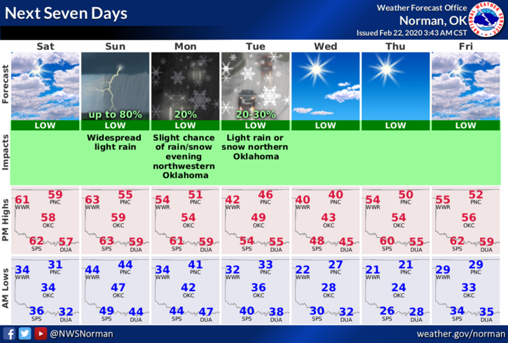
4- Here is your forecast from the NWS/NORMAN;
Saturday-Partly sunny with a high near 59. South wind 10 to 15 mph, with gusts as high as 23 mph.
Saturday Night-30 percent chance of showers after midnight. Mostly cloudy with a low around 45. South wind 10 to 15 mph.
HAVE A GREAT DAY!!
MIKE