0420L-SATURDAY UPDATE FROM GARFIELD COUNTY EMERGENCY MANAGEMENT-2/24/18
1- THE “GOVERNOR’S” BURN BAN HAS BEEN LIFTED FOR ALL BUT 16 COUNTIES. 6 OTHER COUNTIES HAVE A “COUNTY”BURN BAN IN EFFECT. HERE IS A LINK TO THAT INFO: http://www.forestry.ok.gov/burn-ban-info
2- There is a threat for severe weather in southeastern Oklahoma so if you plan on traveling that way, check your forecast!! It’s still slick up north too. Check the forecast before traveling. ALSO, if you go to our website www.gcem.org you can get a lot of info that a many of you have ask for in the past.
3- It’s a bit foggy outside and so far, visibility isn’t real bad BUT be extremely careful as it will be better and worse in some areas. Temps are above freezing so there shouldn’t be travel issues. If you experience “freezing fog” in a particular area, EMAIL me at mike@gcem.org or send me a DAMAGE REPORT that you’ll find on our GARFIELD COUNTY EM app and let me know.
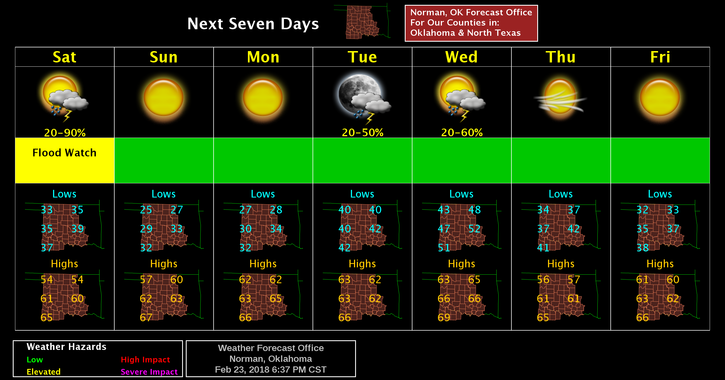
4-Here is your forecast from the NWS/NORMAN;
Saturday-Drizzle and possibly a thunderstorm before 9am, then a chance of showers and thunderstorms between 9am and noon. Widespread fog before 9am. Otherwise, mostly cloudy, with a high near 45. North northeast wind 5 to 10 mph becoming west 15 to 25 mph in the afternoon. Winds could gust as high as 30 mph. Chance of precipitation is 40%.
Saturday Night-Clear, with a low around 26. West northwest wind 10 to 15 mph becoming light and variable after midnight. Winds could gust as high as 25 mph.
HAVE A GREAT DAY, STAY WARM AND SAFE.
MIKE