0255L-SATURDAY OUTLOOK FROM GARFIELD COUNTY EMERGENCY MANAGEMENT 01/13/24
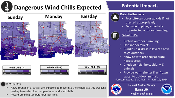
**WIND CHILL WARNING IN EFFECT FROM 0600 TODAY UNTIL NOON ON TUESDAY. Dangerous wind chill temps as low as -15 to -25 degrees are expected. These wind chill temps can cause frostbite on uncovered skin within 30 minutes or less. EXTREME CAUTION IS ADVISED.
*Another ARCTIC front will push in early this morning bringing much colder air with it. No snow with this one BUT if we cloud up, there could be a few flurries but don’t get too excited. Our high today won’t get out of the MID-TEENS and with the wind, it will be brutally cold. I CAN’T STRESS ENOUGH that if you are going to be outdoors for a long length of time to cover your skin as best possible and cover your mouth and breath warmer air.
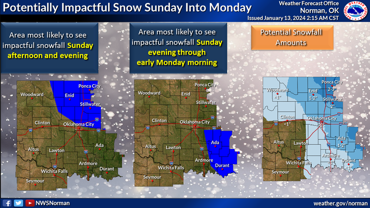
*We’ll have several waves of reinforcing air that will move through the area over the weekend but the snow chances for Sunday into Monday are looking a bit bleak right now. We could still see 1-2 inches but even those totals look a bit bleak too. We’ll wait and see how future forecasts verify.
*MAIN THING right now is the temps. We are not accustomed to these low temps so use caution while outdoors. Overall, we’ll be ok but we’ll feel like ice cubes so here is your forecast from the NWS/NORMAN;
Today- Mostly sunny. Colder with highs around 16. North winds 15 to 20 mph with gusts up to 30 mph. Wind chill values as low as 13 below this morning.
Tonight- Mostly clear. Cold with lows around 2 above. North winds 10 to 15 mph. Wind chill values as low as 11 below.
FINALLY, and don’t kill the messenger but we will see warmer temps around mid-week and then another possible arctic outbreak MIGHT occur. Just be prepared.
STAY WARM AND HAVE A GOOD DAY!