0250L-FRIDAY OUTLOOK FROM GARFIELD COUNTY EMERGENCY MANAGEMENT 01/12/24
WIND CHILL ADVISORY IN EFFECT FROM NOW UNTIL 0900L THIS MORNING. WIND CHILL TEMPS TO MINUS 10 ARE POSSIBLE.
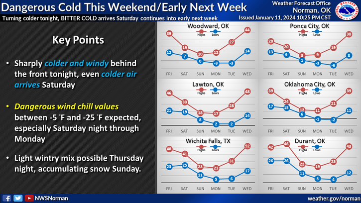
*A WIND CHILL WATCH will be in effect from Saturday evening through Tuesday morning. Wind chill temps as low at minus 25 are possible as ARCTIC air settles in.
DOWNLOAD our GARFIELD COUNTY EM app. You will need it this Winter and Spring for info from us and the NWS. I know that advisories and warnings may come often but the NWS controls that part. Understand that if you don’t want to receive NOAA warnings, etc, you can turn them off in the settings under notification settings.
*At 0245, we have some light snow flurries out there and the wind chill is -2 degrees. Temperature is 17 with winds from the north at 25 gusting to 34mph. Temps this afternoon may make it up to 35 with partly sunny skies.
*The main threat between now and Tuesday will be low temps and wind chill temps with the arctic air that is coming. Just be sure to cover your skin if you have to be out and don’t get to a point where you are shivering violently. That is a bad sign of hypothermia setting in. I will check with some other entities concerning warming stations here in the Enid area. If your town or group opens any warming stations, PLEASE LET ME KNOW so we can get that info out there.
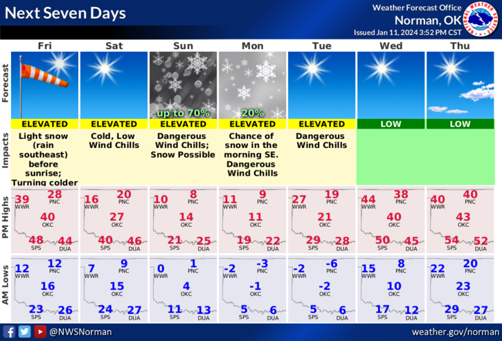
*Overall, we’ll be ok so here is your forecast from the NWS/NORMAN;
Today-Sunny, brisk and much cooler with highs in the mid-30s. Northwest winds 15 to 25 mph with gusts up to 35 mph. Wind chill values as low as 6 below this morning.
Tonight-Clear, cold with lows around 10 above. Northeast winds around 5 mph, increasing to 10 to 15 mph after midnight. Wind chill values as low as 1 below after midnight.
HAVE A GOOD DAY!